
Magnitude |
4.9 |
| Date & Time (UTC) | 2011-05-08 22:17:38.0 |
| Date & Time (Local) | 1390/2/19 02:47:38.0 |
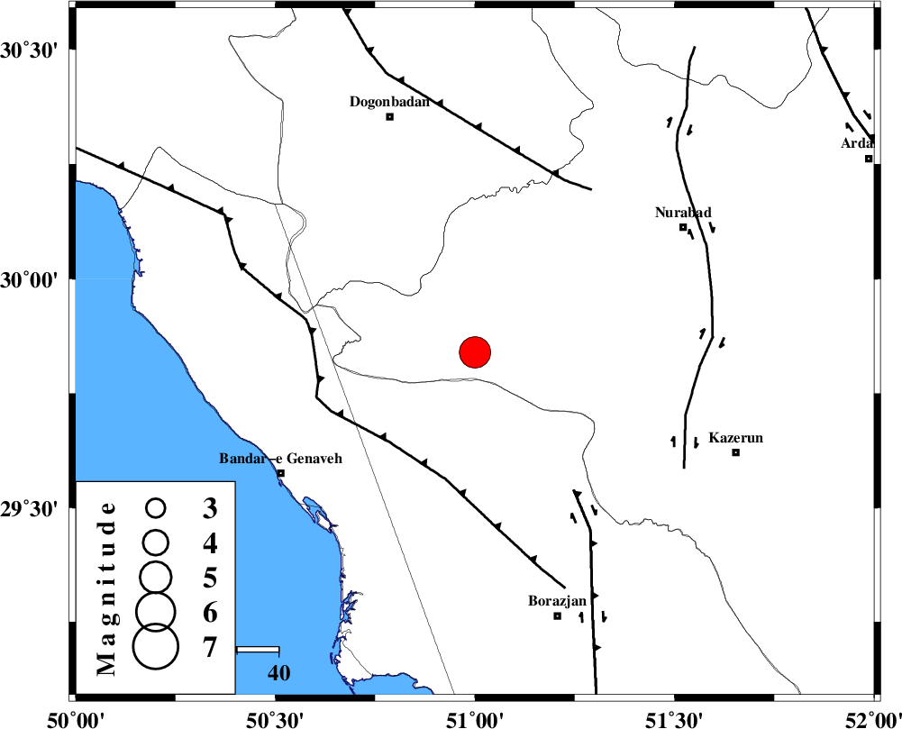
| Location | Lat:29.84 Lon: 51 |
| Region | Fars Province, 60 km South-East of Dogonbadan |
Nearest Cities |
|
| 32 km South West of Babamonir, Fars Province | |
| 39 km North East of Chehar rustaee, Bushehr Province | |
| 41 km North of Dehkohneh, Bushehr Province | |
| 43 km North East of Mohammad salehi, Bushehr Province | |
| 45 km North West of Khesht, Fars Province | |
| Depth | 42 km |
| Agency | |
Faults within 150 km: |
|
| ZFF3 (Length: 125 km) , Distance to epicenter: 30 km | |
| BORAZJAN_F (Length: 168 km) , Distance to epicenter: 41 km | |
| MISHAN_F (Length: 76 km) , Distance to epicenter: 47 km | |
| Number of Phases | 8 |
| RMS | 0.1 |
| Number of Stations | 6 |
| Error in Latitude | >2.3 km |
| Error in Longitude | 2.3 km |
| Error in Depth | 4 km |
Download waveform in seisan format
to download seisan software Click here
to access information about IIEES stations Click here
Amplitude | ||||||||
| UID | Agency | Station | Component | Amplitude | Period | Arrival Time | Proccessing Time | Signal Clip |
| 78896 | IIEES | AHRM | N | 33440.6 | 0.68 | 2011-05-08 22:18:17 | 2011-05-08 10:33:00 | n |
| 78897 | IIEES | AHRM | E | 26532.2 | 0.56 | 2011-05-08 22:18:19 | 2011-05-08 10:33:00 | n |
| 78898 | IIEES | GHIR | N | 4833.8 | 0.48 | 2011-05-08 22:18:59 | 2011-05-08 10:33:00 | n |
| 78899 | IIEES | GHIR | E | 7308.4 | 0.48 | 2011-05-08 22:19:00 | 2011-05-08 10:33:00 | n |
Phase | ||||||||||||
| Agency | Station | Component | Phase Type | Phase Quality | First Motion | Observed Arrival Time | Time Residual | Loc. Flag | Input Weight | Distance | Azimuth | |
| IIEES | AHRM | Z | Pg | E | 2011-05-08 22:17:57 | 0 | y | 112 | 165 | |||
| IIEES | AHRM | E | Sg | E | 2011-05-08 22:18:11 | 0.1 | y | 112 | 165 | |||
| IIEES | GHIR | Z | Pn | E | 2011-05-08 22:18:15 | 0 | y | 259 | 131 | |||
| IIEES | GHIR | N | Sg | E | 2011-05-08 22:18:49 | -0.1 | y | 259 | 131 | |||
| IIEES | SHGR | Z | Pn | E | 2011-05-08 22:18:23 | -0.1 | y | 327 | 321 | |||
| IIEES | NASN | Z | Pn | E | 2011-05-08 22:18:29 | 0.1 | y | 370 | 27 | |||
| IIEES | TABS | Z | P | E | 2011-05-08 22:19:12 | 0.1 | y | 717 | 52 | |||
| IIEES | SHRO | Z | Pn | E | 2011-05-08 22:19:26 | -0.1 | y | 829 | 33 | |||