
Magnitude |
3.3 |
| Date & Time (UTC) | 2011-05-31 15:40:28.5 |
| Date & Time (Local) | 1390/3/10 20:10:28.5 |
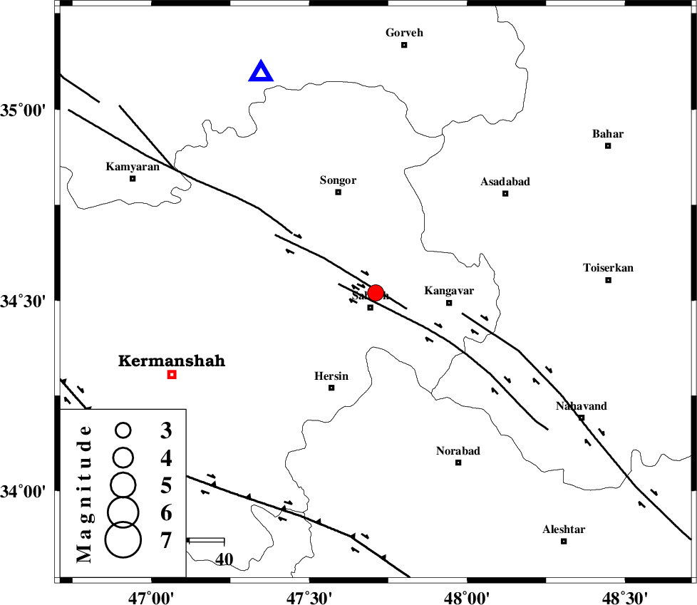
| Location | Lat:34.52 Lon: 47.71 |
| Region | Kermanshah Province, 5 km Sahneh |
Nearest Cities |
|
| 4 km of Dehlaq, Kermanshah Province | |
| 5 km North of Sahneh, Kermanshah Province | |
| 9 km North of Darakeh, Kermanshah Province | |
| 13 km North West of Qazvineh, Kermanshah Province | |
| 14 km North East of Gavgol-e olia, Kermanshah Province | |
| Depth | 15 km |
| Agency | |
Faults within 150 km: |
|
| DINEHVAR_F (Length: 46 km) , Distance to epicenter: 10 km | |
| SAHANEH_F (Length: 77 km) , Distance to epicenter: 11 km | |
| NAHAVAND_F (Length: 102 km) , Distance to epicenter: 26 km | |
| Number of Phases | 3 |
| RMS | 0 |
| Number of Stations | 3 |
| Error in Latitude | >5.8 km |
| Error in Longitude | 5.5 km |
| Error in Depth | 0 km |
Download waveform in seisan format
to download seisan software Click here
to access information about IIEES stations Click here
Amplitude | ||||||||
| UID | Agency | Station | Component | Amplitude | Period | Arrival Time | Proccessing Time | Signal Clip |
| 79192 | IIEES | SNGE | N | 2147.1 | 0.38 | 2011-05-31 15:40:51 | 2011-05-31 04:02:00 | n |
| 79193 | IIEES | SNGE | E | 2835.5 | 0.52 | 2011-05-31 15:40:52 | 2011-05-31 04:02:00 | n |
| 79194 | IIEES | KHMZ | N | 108.7 | 0.15 | 2011-05-31 15:41:43 | 2011-05-31 04:02:00 | n |
Phase | ||||||||||||
| Agency | Station | Component | Phase Type | Phase Quality | First Motion | Observed Arrival Time | Time Residual | Loc. Flag | Input Weight | Distance | Azimuth | |
| IIEES | SNGE | Z | Pg | E | 2011-05-31 15:40:41 | 0 | y | 71.1 | 333 | |||
| IIEES | ASAO | Z | Pg | E | 2011-05-31 15:41:03 | 0 | y | 213 | 89 | |||
| IIEES | KHMZ | Z | Pg | E | 2011-05-31 15:41:05 | 0 | y | 226 | 112 | |||