
Magnitude |
2.8 |
| Date & Time (UTC) | 2011-06-03 00:41:31.6 |
| Date & Time (Local) | 1390/3/13 05:11:31.6 |
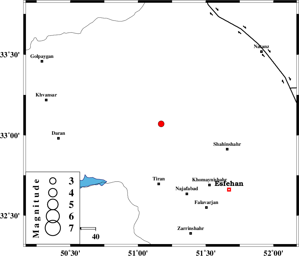
| Location | Lat:33.07 Lon: 51.17 |
| Region | Esfahan Province, 41 km North of Tiran |
Nearest Cities |
|
| 5 km North of Alavijeh, Esfahan Province | |
| 13 km North East of Hoseinieh, Esfahan Province | |
| 16 km North East of Hoseynabad, Esfahan Province | |
| 21 km East of Dehaq, Esfahan Province | |
| 29 km West of Murcheh khort, Esfahan Province | |
| Depth | 14 km |
| Agency | |
Faults within 150 km: |
|
| ZEFREH_F (Length: 124 km) , Distance to epicenter: 84 km | |
| KASHAN_F (Length: 44 km) , Distance to epicenter: 88 km | |
| CHAH_ZANGUL_F (Length: 123 km) , Distance to epicenter: 92 km | |
| Number of Phases | 5 |
| RMS | 0.1 |
| Number of Stations | 4 |
| Error in Latitude | >4.6 km |
| Error in Longitude | 2.9 km |
| Error in Depth | 5.5 km |
Download waveform in seisan format
to download seisan software Click here
to access information about IIEES stations Click here
Amplitude | ||||||||
| UID | Agency | Station | Component | Amplitude | Period | Arrival Time | Proccessing Time | Signal Clip |
| 79206 | IIEES | KHMZ | N | 165 | 0.28 | 2011-06-03 00:42:13 | 2011-06-03 01:04:00 | n |
| 79207 | IIEES | KHMZ | E | 157.8 | 0.24 | 2011-06-03 00:42:15 | 2011-06-03 01:04:00 | n |
| 79208 | IIEES | NASN | N | 271.1 | 0.2 | 2011-06-03 00:42:18 | 2011-06-03 01:04:00 | n |
| 79209 | IIEES | NASN | E | 260.3 | 0.24 | 2011-06-03 00:42:19 | 2011-06-03 01:04:00 | n |
| 79210 | IIEES | GHVR | E | 109 | 0.32 | 2011-06-03 00:42:18 | 2011-06-03 01:04:00 | n |
| 79211 | IIEES | GHVR | N | 136.7 | 0.28 | 2011-06-03 00:42:18 | 2011-06-03 01:04:00 | n |
| 79212 | IIEES | ASAO | N | 90.5 | 0.56 | 2011-06-03 00:42:28 | 2011-06-03 01:04:00 | n |
| 79213 | IIEES | ASAO | E | 64.3 | 0.44 | 2011-06-03 00:42:28 | 2011-06-03 01:04:00 | n |
Phase | ||||||||||||
| Agency | Station | Component | Phase Type | Phase Quality | First Motion | Observed Arrival Time | Time Residual | Loc. Flag | Input Weight | Distance | Azimuth | |
| IIEES | KHMZ | Z | Pg | E | 2011-06-03 00:41:54 | 0.2 | y | 135 | 304 | |||
| IIEES | KHMZ | N | Sg | E | 2011-06-03 00:42:10 | -0.1 | y | 135 | 304 | |||
| IIEES | NASN | Z | Pg | E | 2011-06-03 00:41:57 | -0.1 | y | 156 | 100 | |||
| IIEES | GHVR | Z | Pg | E | 2011-06-03 00:41:57 | 0 | y | 157 | 3 | |||
| IIEES | ASAO | Z | Pn | E | 2011-06-03 00:42:03 | 0 | y | 196 | 327 | |||