
Magnitude |
3 |
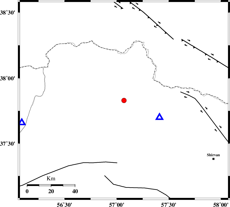
| Date & Time (UTC) | 2011-06-04 21:45:54.2 |
| Date & Time (Local) | 1390/3/15 02:15:54.2 |
| Location | Lat:37.83 Lon: 57.07 |
| Region | Khorasan(north) Province, 33 km North-East of Ashkhaneh |
Nearest Cities |
|
| 13 km South of Raz, Khorasan(north) Province | |
| 18 km South East of Tangehzar, Khorasan(north) Province | |
| 21 km North of Pish qaleh, Khorasan(north) Province | |
| 33 km North East of Ashkhaneh, Khorasan(north) Province | |
| 37 km West of Gifan olia, Khorasan(north) Province | |
| Depth | 42 km |
| Agency | |
Faults within 150 km: |
|
| BAGHAN_GERMAB_F (Length: 79 km) , Distance to epicenter: 48 km | |
| ROBATE_QARABIL_F (Length: 168 km) , Distance to epicenter: 54 km | |
| ESFARAYEN_F (Length: 111 km) , Distance to epicenter: 66 km | |
| Number of Phases | 4 |
| RMS | 0 |
| Number of Stations | 3 |
| Error in Latitude | >6 km |
| Error in Longitude | 1.9 km |
| Error in Depth | 6.9 km |
Download waveform in seisan format
to download seisan software Click here
to access information about IIEES stations Click here
Amplitude | ||||||||
| UID | Agency | Station | Component | Amplitude | Period | Arrival Time | Proccessing Time | Signal Clip |
| 79225 | IIEES | MRVT | N | 438.7 | 0.43 | 2011-06-04 21:46:26 | 2011-06-04 10:56:00 | n |
| 79226 | IIEES | MRVT | E | 775.9 | 0.43 | 2011-06-04 21:46:28 | 2011-06-04 10:56:00 | n |
| 79227 | IIEES | SHRO | N | 66.3 | 0 | 2011-06-04 21:46:59 | 2011-06-04 10:56:00 | n |
Phase | ||||||||||||
| Agency | Station | Component | Phase Type | Phase Quality | First Motion | Observed Arrival Time | Time Residual | Loc. Flag | Input Weight | Distance | Azimuth | |
| IIEES | BJRD | Z | Pg | E | 2011-06-04 21:46:03 | 0 | y | 33.1 | 115 | |||
| IIEES | MRVT | Z | Pg | E | 2011-06-04 21:46:09 | 0 | y | 88.2 | 258 | |||
| IIEES | MRVT | N | Sg | E | 2011-06-04 21:46:21 | 0 | y | 88.2 | 258 | |||
| IIEES | SHRO | N | Pg | E | 2011-06-04 21:46:30 | 0 | y | 222 | 205 | |||