
Magnitude |
3.5 |
| Date & Time (UTC) | 2011-06-08 09:43:42.8 |
| Date & Time (Local) | 1390/3/18 14:13:42.8 |
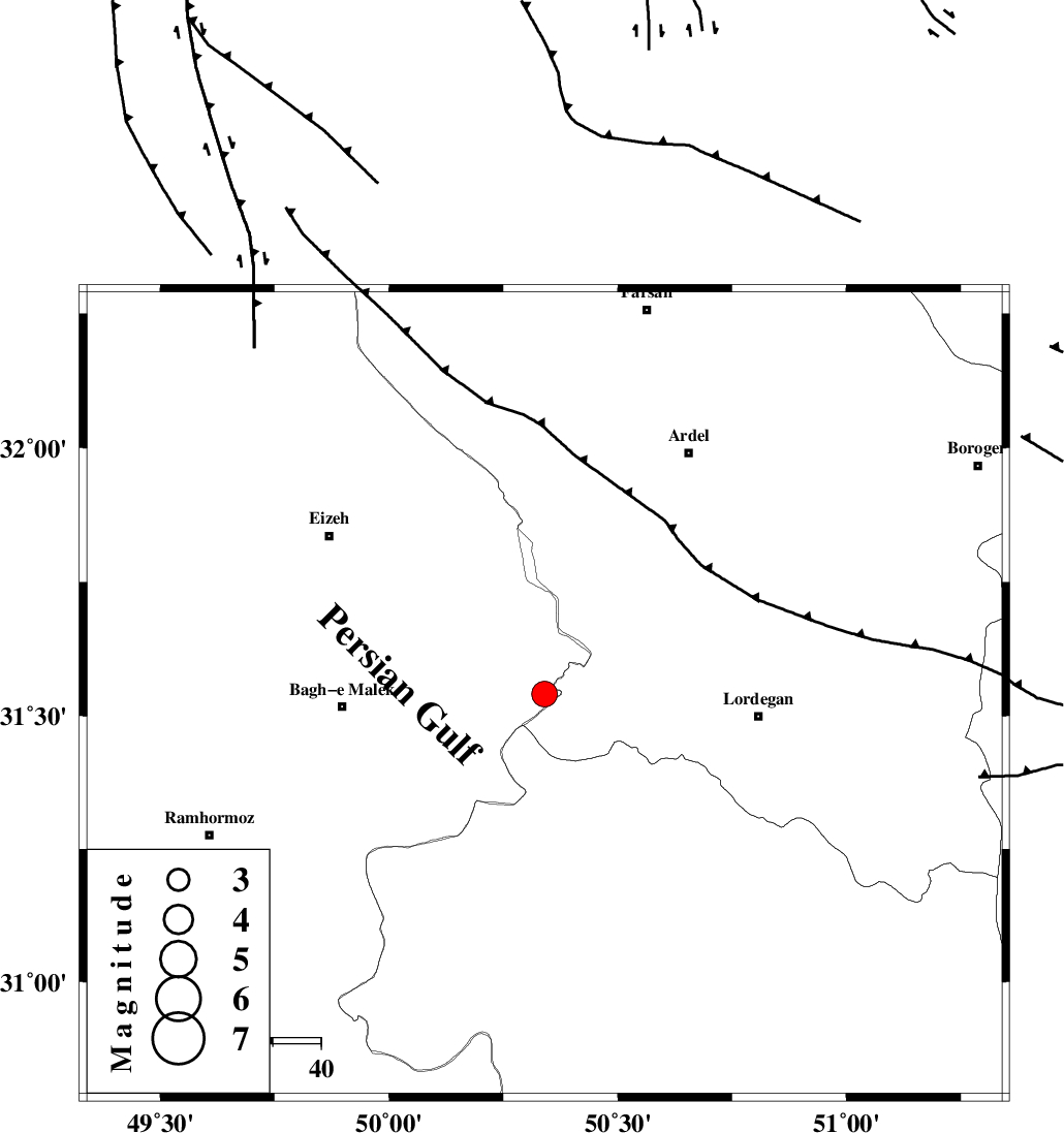
| Location | Lat:31.54 Lon: 50.34 |
| Region | Khoozestan Province, 42 km East of Bagh Malek |
Nearest Cities |
|
| 24 km South of Dehdez, Khoozestan Province | |
| 28 km North of Dishmuk, Kohkiluieh va boyerahmad Province | |
| 29 km North of Esfandan, Kohkiluieh va boyerahmad Province | |
| 30 km South West of Sarkhun, Chaharmahal Bakhtiari Province | |
| 32 km North East of Seidun, Khoozestan Province | |
| Depth | 15 km |
| Agency | |
Faults within 150 km: |
|
| MFF2 (Length: 205 km) , Distance to epicenter: 26 km | |
| SABZKUH_F (Length: 67 km) , Distance to epicenter: 27 km | |
| DOPOLAN_F (Length: 107 km) , Distance to epicenter: 38 km | |
| Number of Phases | 5 |
| RMS | 0.2 |
| Number of Stations | 5 |
| Error in Latitude | >2.7 km |
| Error in Longitude | 3.9 km |
| Error in Depth | 0 km |
Download waveform in seisan format
to download seisan software Click here
to access information about IIEES stations Click here
Amplitude | ||||||||
| UID | Agency | Station | Component | Amplitude | Period | Arrival Time | Proccessing Time | Signal Clip |
| 79254 | IIEES | KHMZ | E | 410.6 | 0.62 | 2011-06-08 09:44:54 | 2011-06-08 10:04:00 | n |
| 79255 | IIEES | KHMZ | N | 229.6 | 0.43 | 2011-06-08 09:44:57 | 2011-06-08 10:04:00 | n |
| 79256 | IIEES | NASN | N | 314.4 | 0.66 | 2011-06-08 09:45:05 | 2011-06-08 10:04:00 | n |
| 79257 | IIEES | NASN | E | 178.9 | 0.56 | 2011-06-08 09:45:16 | 2011-06-08 10:04:00 | n |
Phase | ||||||||||||
| Agency | Station | Component | Phase Type | Phase Quality | First Motion | Observed Arrival Time | Time Residual | Loc. Flag | Input Weight | Distance | Azimuth | |
| IIEES | KHMZ | Z | Pn | E | 2011-06-08 09:44:20 | -0.3 | y | 246 | 352 | |||
| IIEES | NASN | Z | Pn | E | 2011-06-08 09:44:24 | -0.1 | y | 272 | 58 | |||
| IIEES | AHRM | Z | Pn | E | 2011-06-08 09:44:28 | 0 | y | 311 | 162 | |||
| IIEES | ASAO | Z | Pn | E | 2011-06-08 09:44:32 | 0.2 | y | 335 | 355 | |||
| IIEES | GHVR | Z | Pn | E | 2011-06-08 09:44:32 | 0.2 | y | 337 | 14 | |||