
Magnitude |
3 |
| Date & Time (UTC) | 2011-06-13 10:08:12.6 |
| Date & Time (Local) | 1390/3/23 14:38:12.6 |
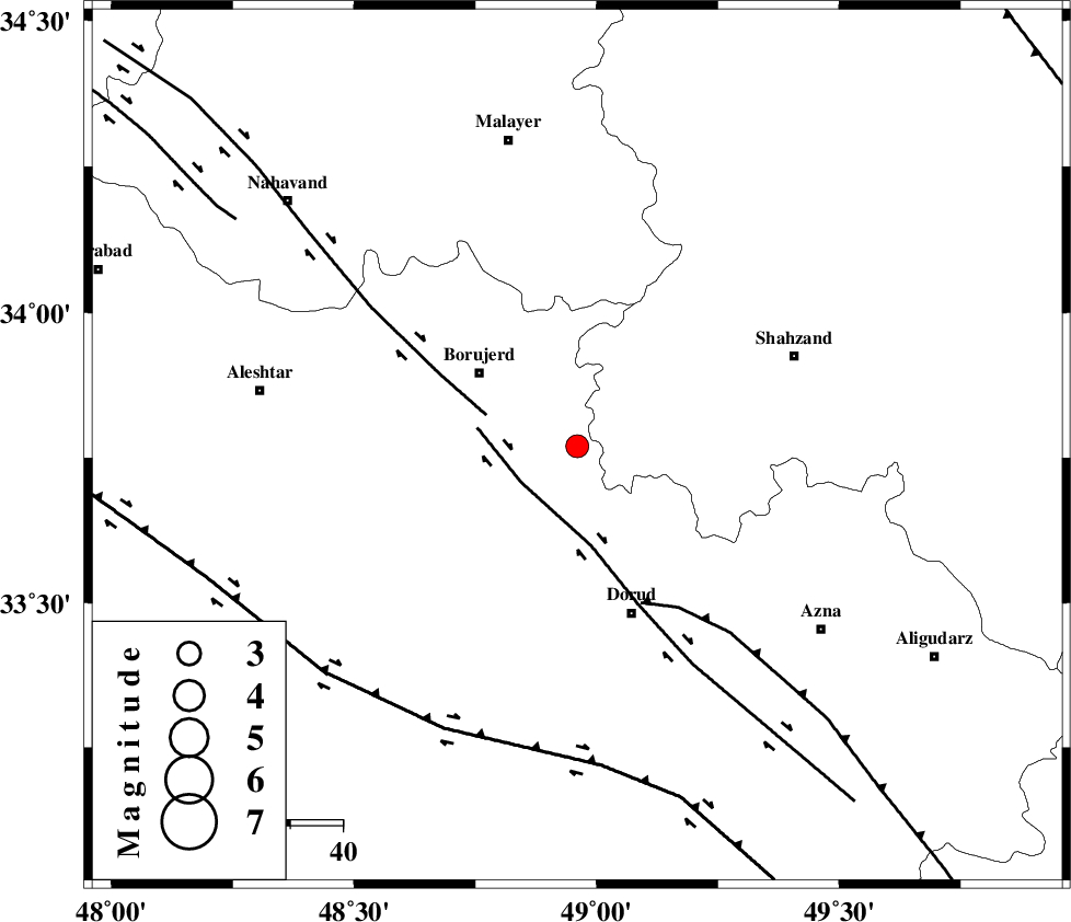
| Location | Lat:33.77 Lon: 48.96 |
| Region | Lorestan Province, 23 km South-East of Borujerd |
Nearest Cities |
|
| 10 km West of Hashian, Markazi Province | |
| 14 km North of Chalanchulan, Lorestan Province | |
| 16 km East of Valanjerd, Lorestan Province | |
| 17 km East of Hemmatabad, Lorestan Province | |
| 18 km North of Kagheh, Lorestan Province | |
| Depth | 15 km |
| Agency | |
Faults within 150 km: |
|
| DORUD (Length: 100 km) , Distance to epicenter: 13 km | |
| NAHAVAND_F (Length: 102 km) , Distance to epicenter: 18 km | |
| MAIN_ZAGROS_R_F (Length: 1106 km) , Distance to epicenter: 32 km | |
| Number of Phases | 7 |
| RMS | 0.5 |
| Number of Stations | 6 |
| Error in Latitude | >6.7 km |
| Error in Longitude | 6.6 km |
| Error in Depth | 10.1 km |
Download waveform in seisan format
to download seisan software Click here
to access information about IIEES stations Click here
Amplitude | ||||||||
| UID | Agency | Station | Component | Amplitude | Period | Arrival Time | Proccessing Time | Signal Clip |
| 79287 | IIEES | ASAO | N | 295 | 0.49 | 2011-06-13 10:08:56 | 2011-06-13 10:25:00 | n |
| 79288 | IIEES | SHGR | N | 212.4 | 0.49 | 2011-06-13 10:09:10 | 2011-06-13 10:25:00 | n |
| 79289 | IIEES | GHVR | N | 101.1 | 0.53 | 2011-06-13 10:09:24 | 2011-06-13 10:25:00 | n |
| 79290 | IIEES | GHVR | E | 79.1 | 0.6 | 2011-06-13 10:09:26 | 2011-06-13 10:25:00 | n |
Phase | ||||||||||||
| Agency | Station | Component | Phase Type | Phase Quality | First Motion | Observed Arrival Time | Time Residual | Loc. Flag | Input Weight | Distance | Azimuth | |
| IIEES | KHMZ | Z | Pg | E | 2011-06-13 10:08:28 | -0.5 | y | 93.2 | 92 | |||
| IIEES | KHMZ | E | Sg | E | 2011-06-13 10:08:40 | -0.2 | y | 93.2 | 92 | |||
| IIEES | ASAO | Z | Pg | E | 2011-06-13 10:08:34 | 0 | y | 131 | 49 | |||
| IIEES | SHGR | Z | Pg | E | 2011-06-13 10:08:43 | 0.1 | y | 185 | 185 | |||
| IIEES | SNGE | Z | Pn | E | 2011-06-13 10:08:45 | -0.3 | y | 208 | 315 | |||
| IIEES | GHVR | Z | Pn | E | 2011-06-13 10:08:49 | 1 | y | 225 | 69 | |||
| IIEES | NASN | Z | Pn | E | 2011-06-13 10:09:06 | -0.1 | y | 374 | 106 | |||