
Magnitude |
4.3 |
| Date & Time (UTC) | 2011-06-15 01:10:51.1 |
| Date & Time (Local) | 1390/3/25 05:40:51.1 |
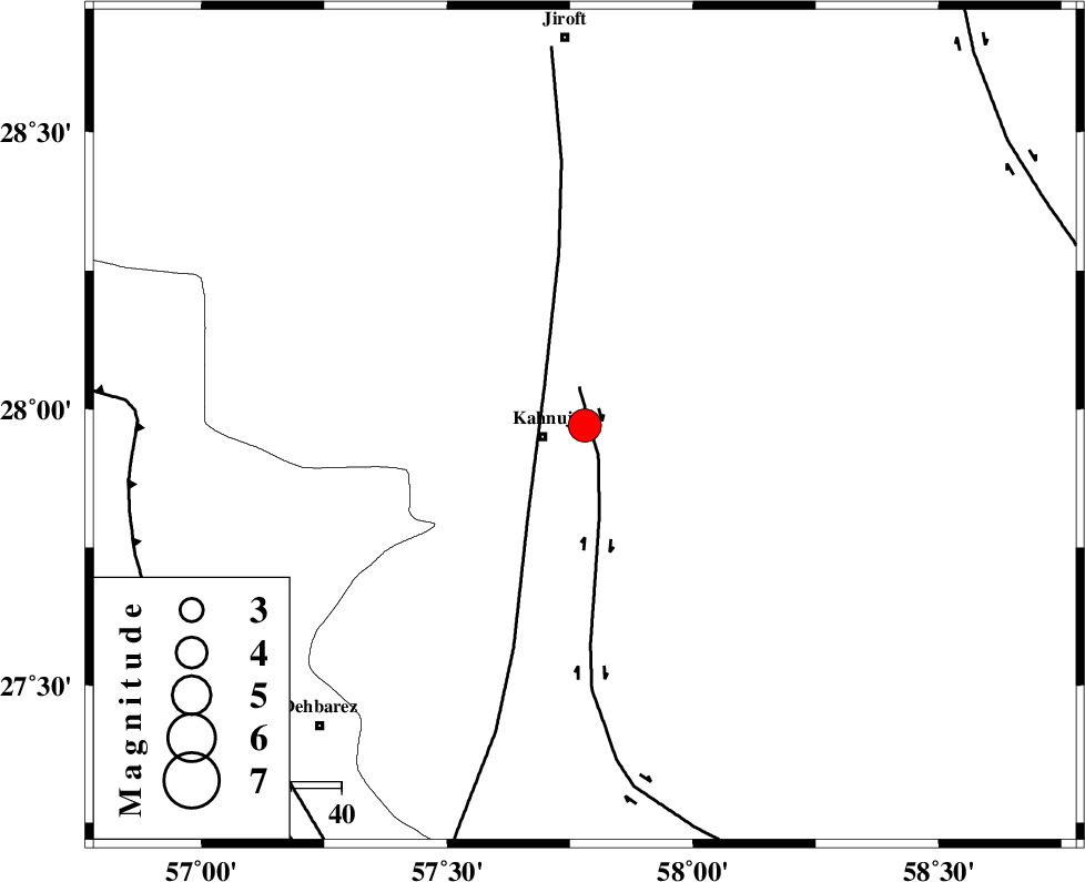
| Location | Lat:27.97 Lon: 57.78 |
| Region | Kerman Province, 8 km Kahnuj |
Nearest Cities |
|
| 9 km North of Kahnuj, Kerman Province | |
| 36 km South East of Bolock, Kerman Province | |
| 39 km South East of Mehrueye-e paeen, Kerman Province | |
| 39 km North East of Bargah, Kerman Province | |
| 50 km North West of Qalehy-eganj, Kerman Province | |
| Depth | 15 km |
| Agency | |
Faults within 150 km: |
|
| JIROFT_F (Length: 144 km) , Distance to epicenter: 7 km | |
| SABZEVARAN_F (Length: 190 km) , Distance to epicenter: 11 km | |
| ZENDAN_MINAB_F_Z1 (Length: 183 km) , Distance to epicenter: 88 km | |
| Number of Phases | 3 |
| RMS | 0 |
| Number of Stations | 3 |
| Error in Latitude | >2.3 km |
| Error in Longitude | 2.2 km |
| Error in Depth | 0 km |
Download waveform in seisan format
to download seisan software Click here
to access information about IIEES stations Click here
Amplitude | ||||||||
| UID | Agency | Station | Component | Amplitude | Period | Arrival Time | Proccessing Time | Signal Clip |
| 79311 | IIEES | BNDS | N | 6341.6 | 0.46 | 2011-06-15 01:11:42 | 2011-06-15 02:04:00 | n |
| 79312 | IIEES | BNDS | E | 5202 | 1.22 | 2011-06-15 01:11:43 | 2011-06-15 02:04:00 | n |
| 79313 | IIEES | KRBR | N | 1119.9 | 0.5 | 2011-06-15 01:12:08 | 2011-06-15 02:04:00 | n |
| 79314 | IIEES | KRBR | E | 1557.3 | 0.07 | 2011-06-15 01:12:11 | 2011-06-15 02:04:00 | n |
Phase | ||||||||||||
| Agency | Station | Component | Phase Type | Phase Quality | First Motion | Observed Arrival Time | Time Residual | Loc. Flag | Input Weight | Distance | Azimuth | |
| IIEES | BNDS | Z | Pg | E | 2011-06-15 01:11:19 | 0 | y | 170 | 249 | |||
| IIEES | KRBR | Z | Pg | E | 2011-06-15 01:11:31 | 0 | y | 244 | 336 | |||
| IIEES | ZHSF | Z | Pn | E | 2011-06-15 01:11:41 | 0 | y | 345 | 57 | |||