
Magnitude |
3.2 |
| Date & Time (UTC) | 2011-12-17 08:10:11.7 |
| Date & Time (Local) | 1390/9/26 11:40:11.7 |
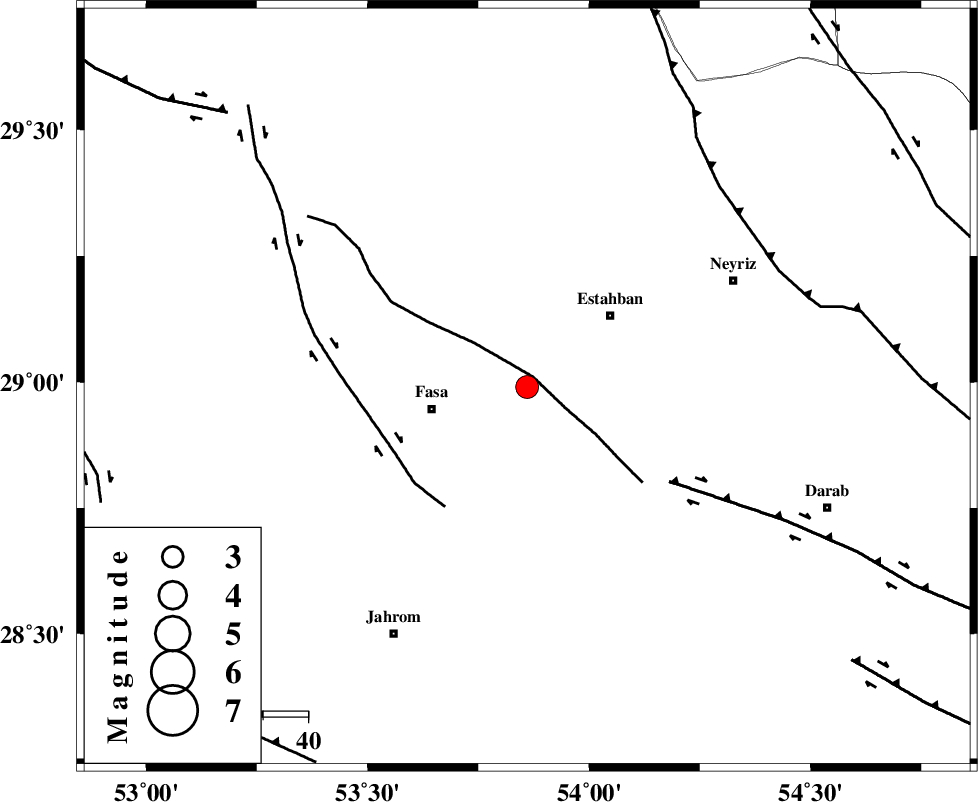
| Location | Lat:28.99 Lon: 53.86 |
| Region | Fars Province, 21 km East of Fasa |
Nearest Cities |
|
| 16 km North of Nobandegan, Fars Province | |
| 17 km North West of Sheshdah, Fars Province | |
| 21 km North East of Sahrarud, Fars Province | |
| 21 km North East of Fasa, Fars Province | |
| 23 km North East of Fadashkueyeh, Fars Province | |
| Depth | 6 km |
| Agency | |
Faults within 150 km: |
|
| BAKHTEGAN_F (Length: 94 km) , Distance to epicenter: 3 km | |
| SARVESTAN_F (Length: 94 km) , Distance to epicenter: 32 km | |
| HZF1 (Length: 102 km) , Distance to epicenter: 38 km | |
| Number of Phases | 5 |
| RMS | 0.1 |
| Number of Stations | 5 |
| Error in Latitude | >3.1 km |
| Error in Longitude | 2.5 km |
| Error in Depth | 6.2 km |
Download waveform in seisan format
to download seisan software Click here
to access information about IIEES stations Click here
Amplitude | ||||||||
| UID | Agency | Station | Component | Amplitude | Period | Arrival Time | Proccessing Time | Signal Clip |
| 81018 | IIEES | GHIR | N | 523.1 | 0.54 | 2011-12-17 08:10:50 | 2011-12-17 08:21:00 | n |
| 81019 | IIEES | GHIR | E | 755 | 0.39 | 2011-12-17 08:10:55 | 2011-12-17 08:21:00 | n |
| 81020 | IIEES | AHRM | N | 137.2 | 0.52 | 2011-12-17 08:11:27 | 2011-12-17 08:21:00 | n |
| 81021 | IIEES | AHRM | E | 154.1 | 0.52 | 2011-12-17 08:11:30 | 2011-12-17 08:21:00 | n |
Phase | ||||||||||||
| Agency | Station | Component | Phase Type | Phase Quality | First Motion | Observed Arrival Time | Time Residual | Loc. Flag | Input Weight | Distance | Azimuth | |
| IIEES | GHIR | Z | Pg | E | 2011-12-17 08:10:31 | -0.12 | y | 115 | 228 | |||
| IIEES | AHRM | Z | Pn | E | 2011-12-17 08:10:51 | 0.11 | y | 250 | 267 | |||
| IIEES | BNDS | Z | P | E | 2011-12-17 08:10:56 | 0.13 | y | 288 | 127 | |||
| IIEES | KRBR | Z | P | E | 2011-12-17 08:10:58 | -0.12 | y | 303 | 68 | |||
| IIEES | NASN | Z | Pn | E | 2011-12-17 08:11:14 | 0.01 | y | 434 | 347 | |||