
Magnitude |
3.6 |
| Date & Time (UTC) | 2012-01-19 17:04:48.1 |
| Date & Time (Local) | 1390/10/29 20:34:48.1 |
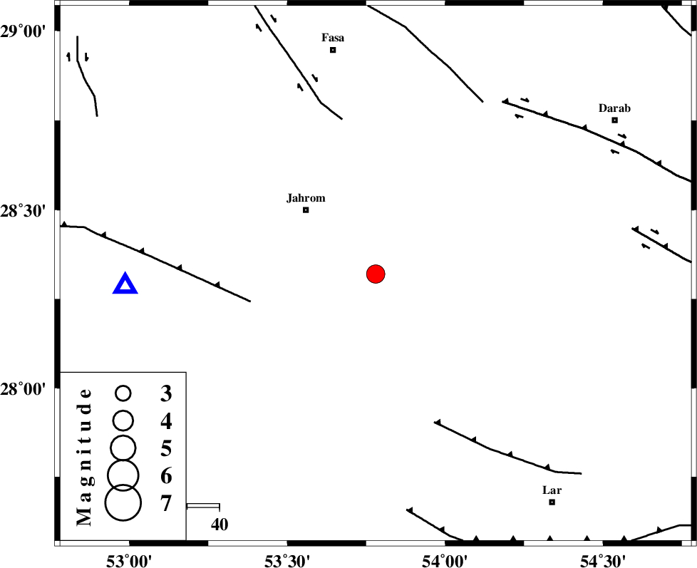
| Location | Lat:28.32 Lon: 53.78 |
| Region | Fars Province, 29 km South-East of Jahrom |
Nearest Cities |
|
| 16 km South of Khorramabad, Fars Province | |
| 18 km North of Juyam, Fars Province | |
| 26 km North East of Balafan, Fars Province | |
| 29 km East of Hasanabad, Fars Province | |
| 29 km South East of Jahrom, Fars Province | |
| Depth | 46 km |
| Agency | |
Faults within 150 km: |
|
| QIR_F (Length: 130 km) , Distance to epicenter: 40 km | |
| SARVESTAN_F (Length: 94 km) , Distance to epicenter: 49 km | |
| BERIZ_F (Length: 49 km) , Distance to epicenter: 50 km | |
| Number of Phases | 5 |
| RMS | 0.4 |
| Number of Stations | 4 |
| Error in Latitude | >7.4 km |
| Error in Longitude | 3.7 km |
| Error in Depth | 8.6 km |
Download waveform in seisan format
to download seisan software Click here
to access information about IIEES stations Click here
Amplitude | ||||||||
| UID | Agency | Station | Component | Amplitude | Period | Arrival Time | Proccessing Time | Signal Clip |
| 81471 | IIEES | GHIR | N | 2149.9 | 0.68 | 2012-01-19 17:05:23 | 2012-01-19 04:49:00 | n |
| 81472 | IIEES | GHIR | E | 2019.1 | 0.44 | 2012-01-19 17:05:24 | 2012-01-19 04:49:00 | n |
| 81473 | IIEES | AHRM | N | 366.5 | 0.52 | 2012-01-19 17:06:15 | 2012-01-19 04:49:00 | n |
| 81474 | IIEES | AHRM | E | 235.1 | 0.56 | 2012-01-19 17:06:17 | 2012-01-19 04:49:00 | n |
Phase | ||||||||||||
| Agency | Station | Component | Phase Type | Phase Quality | First Motion | Observed Arrival Time | Time Residual | Loc. Flag | Input Weight | Distance | Azimuth | |
| IIEES | GHIR | Z | Pg | E | 2012-01-19 17:05:02 | -0.27 | y | 78.1 | 267 | |||
| IIEES | AHRM | N | Sg | E | 2012-01-19 17:05:57 | 0.25 | y | 250 | 284 | |||
| IIEES | BNDS | Z | Pn | E | 2012-01-19 17:05:25 | 0.32 | y | 257 | 113 | |||
| IIEES | KRBR | Z | Pn | E | 2012-01-19 17:05:35 | -0.61 | y | 343 | 57 | |||
| IIEES | KRBR | Z | Sg | E | 2012-01-19 17:06:22 | 0.26 | y | 343 | 57 | |||