
Magnitude |
3.3 |
| Date & Time (UTC) | 2012-01-25 11:14:06.2 |
| Date & Time (Local) | 1390/11/5 14:44:06.2 |
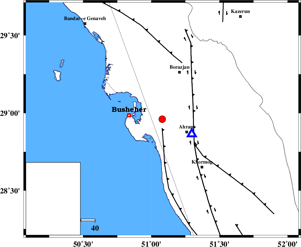
| Location | Lat:28.96 Lon: 51.08 |
| Region | Bushehr Province, 20 km West of Ahram |
Nearest Cities |
|
| 5 km of Choghadak, Bushehr Province | |
| 19 km North West of Bazuei, Bushehr Province | |
| 20 km North West of Ahram, Bushehr Province | |
| 22 km North of Delvar, Bushehr Province | |
| 24 km East of Busheher, Bushehr Province | |
| Depth | 17 km |
| Agency | |
Faults within 150 km: |
|
| ZFF2 (Length: 84 km) , Distance to epicenter: 6 km | |
| BORAZJAN_F (Length: 168 km) , Distance to epicenter: 24 km | |
| MFF5 (Length: 74 km) , Distance to epicenter: 29 km | |
| Number of Phases | 7 |
| RMS | 0.1 |
| Number of Stations | 6 |
| Error in Latitude | >7.9 km |
| Error in Longitude | 7.1 km |
| Error in Depth | 4.7 km |
Download waveform in seisan format
to download seisan software Click here
to access information about IIEES stations Click here
Amplitude | ||||||||
| UID | Agency | Station | Component | Amplitude | Period | Arrival Time | Proccessing Time | Signal Clip |
| 81574 | IIEES | AHRM | N | 3788.8 | 0.16 | 2012-01-25 11:14:16 | 2012-01-25 10:35:00 | n |
| 81575 | IIEES | KHMZ | E | 35.4 | 0.5 | 2012-01-25 11:16:20 | 2012-01-25 10:35:00 | n |
Phase | ||||||||||||
| Agency | Station | Component | Phase Type | Phase Quality | First Motion | Observed Arrival Time | Time Residual | Loc. Flag | Input Weight | Distance | Azimuth | |
| IIEES | AHRM | Z | Pg | E | 2012-01-25 11:14:10 | -0.15 | y | 23.4 | 118 | |||
| IIEES | AHRM | E | Sg | E | 2012-01-25 11:14:14 | 0.11 | y | 23.4 | 118 | |||
| IIEES | GHIR | Z | Pg | E | 2012-01-25 11:14:39 | 0 | y | 201 | 112 | |||
| IIEES | NASN | Z | Pn | E | 2012-01-25 11:15:10 | -0.15 | y | 456 | 21 | |||
| IIEES | KHMZ | Z | Pn | E | 2012-01-25 11:15:21 | 0.2 | y | 540 | 349 | |||
| IIEES | KRBR | Z | Pn | E | 2012-01-25 11:15:23 | 0.03 | y | 562 | 77 | |||
| IIEES | ASAO | Z | Pn | E | 2012-01-25 11:15:31 | 0.01 | y | 627 | 351 | |||