
Magnitude |
2.7 |
| Date & Time (UTC) | 2012-05-09 01:55:56.5 |
| Date & Time (Local) | 1391/2/20 06:25:56.5 |
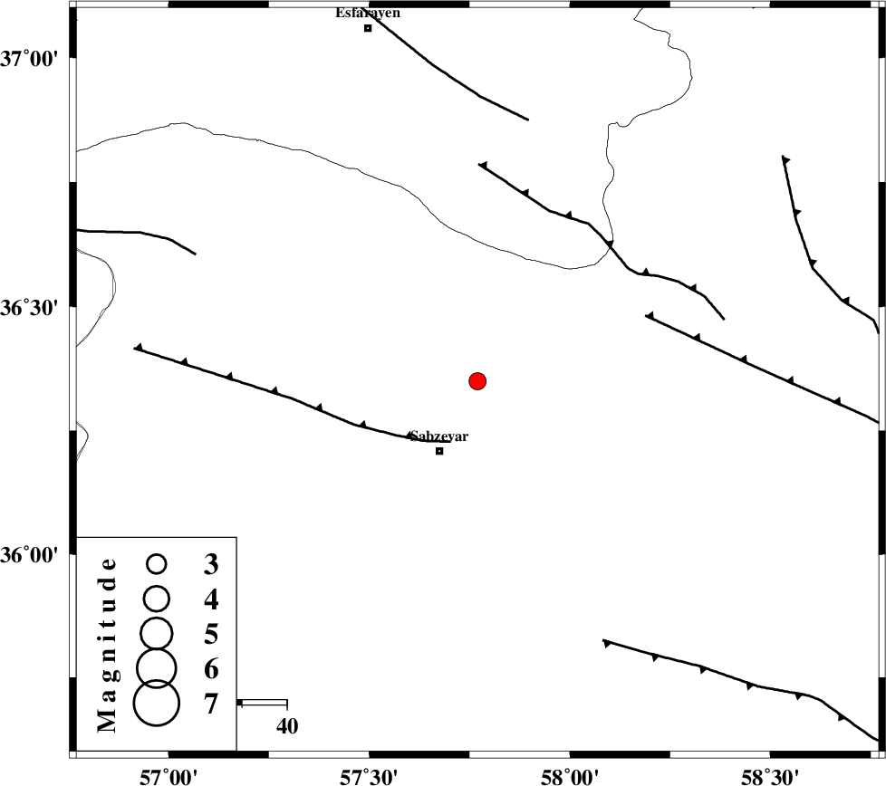
| Location | Lat:36.35 Lon: 57.77 |
| Region | Khorasan(center) Province, 18 km North of Sabzevar |
Nearest Cities |
|
| 18 km North of Sabzevar, Khorasan(center) Province | |
| 25 km South East of Void, Khorasan(center) Province | |
| 25 km South West of Rebatjaz, Khorasan(center) Province | |
| 28 km West of Soltanabad, Khorasan(center) Province | |
| 35 km South East of Hokmabad, Khorasan(center) Province | |
| Depth | 14 km |
| Agency | |
Faults within 150 km: |
|
| SABZEVAR_F (Length: 81 km) , Distance to epicenter: 15 km | |
| NAYSHABUR_F (Length: 74 km) , Distance to epicenter: 40 km | |
| RIVAND_F (Length: 70 km) , Distance to epicenter: 41 km | |
| Number of Phases | 4 |
| RMS | 0 |
| Number of Stations | 3 |
| Error in Latitude | >2.9 km |
| Error in Longitude | 8.5 km |
| Error in Depth | 4 km |
Download waveform in seisan format
to download seisan software Click here
to access information about IIEES stations Click here
Amplitude | ||||||||
| UID | Agency | Station | Component | Amplitude | Period | Arrival Time | Proccessing Time | Signal Clip |
| 83387 | IIEES | BJRD | E | 100.7 | 0.72 | 2012-05-09 01:56:44 | 2012-05-09 02:37:00 | n |
| 83388 | IIEES | SHRO | N | 260.5 | 0.36 | 2012-05-09 01:56:48 | 2012-05-09 02:37:00 | n |
| 83389 | IIEES | SHRO | E | 171.2 | 0.44 | 2012-05-09 01:56:49 | 2012-05-09 02:37:00 | n |
| 83390 | IIEES | MRVT | E | 48.9 | 0.4 | 2012-05-09 01:57:05 | 2012-05-09 02:37:00 | n |
| 83391 | IIEES | MRVT | N | 40.7 | 0.32 | 2012-05-09 01:57:07 | 2012-05-09 02:37:00 | n |
Phase | ||||||||||||
| Agency | Station | Component | Phase Type | Phase Quality | First Motion | Observed Arrival Time | Time Residual | Loc. Flag | Input Weight | Distance | Azimuth | |
| IIEES | BJRD | Z | Pg | E | 2012-05-09 01:56:21 | -0.01 | y | 153 | 348 | |||
| IIEES | BJRD | E | Sg | E | 2012-05-09 01:56:40 | 0 | y | 153 | 348 | |||
| IIEES | SHRO | Z | Pg | E | 2012-05-09 01:56:23 | 0 | y | 162 | 257 | |||
| IIEES | MRVT | Z | Pn | E | 2012-05-09 01:56:30 | 0.01 | y | 208 | 315 | |||