
Magnitude |
3.7 |
| Date & Time (UTC) | 2012-05-09 08:05:48.7 |
| Date & Time (Local) | 1391/2/20 12:35:48.7 |
| Location | Lat:32.7 Lon: 47.17 |
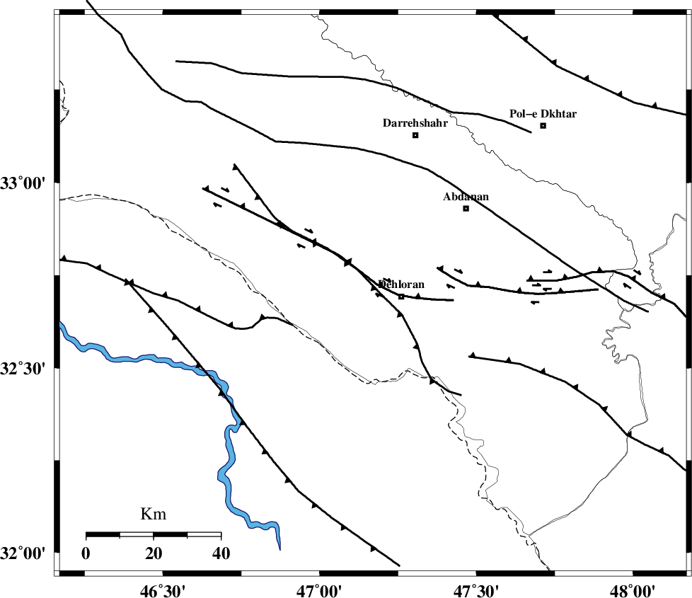
| Region | Ilam Province, 9 km Dehloran |
Nearest Cities |
|
| 8 km North of Dehloran, Ilam Province | |
| 23 km South East of Bishehzar, Ilam Province | |
| 25 km North West of Musian, Ilam Province | |
| 38 km South West of Abdanan, Ilam Province | |
| 43 km South West of Sarabbagh, Ilam Province | |
| Depth | 16 km |
| Agency | |
Faults within 150 km: |
|
| MFF6 (Length: 144 km) , Distance to epicenter: 8 km | |
| BALARUD_F_Z1 (Length: 87 km) , Distance to epicenter: 41 km | |
| BALARUD_F_Z3 (Length: 53 km) , Distance to epicenter: 84 km | |
| Number of Phases | 8 |
| RMS | 0.2 |
| Number of Stations | 8 |
| Error in Latitude | >5.4 km |
| Error in Longitude | 8.3 km |
| Error in Depth | 7.8 km |
Download waveform in seisan format
to download seisan software Click here
to access information about IIEES stations Click here
Amplitude | ||||||||
| UID | Agency | Station | Component | Amplitude | Period | Arrival Time | Proccessing Time | Signal Clip |
| 83416 | IIEES | SHGR | E | 2661.4 | 0.58 | 2012-05-09 08:06:48 | 2012-05-09 08:31:00 | n |
| 83417 | IIEES | GHVR | E | 75.4 | 0.6 | 2012-05-09 08:07:52 | 2012-05-09 08:31:00 | n |
| 83418 | IIEES | GHVR | N | 55.7 | 0.6 | 2012-05-09 08:07:59 | 2012-05-09 08:31:00 | n |
Phase | ||||||||||||
| Agency | Station | Component | Phase Type | Phase Quality | First Motion | Observed Arrival Time | Time Residual | Loc. Flag | Input Weight | Distance | Azimuth | |
| IIEES | SHGR | Z | Pg | E | 2012-05-09 08:06:16 | 0 | y | 168 | 113 | |||
| IIEES | SNGE | Z | Pn | E | 2012-05-09 08:06:29 | -0.16 | y | 265 | 4 | |||
| IIEES | KHMZ | Z | Pn | E | 2012-05-09 08:06:31 | -0.22 | y | 285 | 65 | |||
| IIEES | ASAO | Z | Pn | E | 2012-05-09 08:06:38 | 0.19 | y | 335 | 52 | |||
| IIEES | GHVR | Z | Pn | E | 2012-05-09 08:06:49 | 0.13 | y | 427 | 61 | |||
| IIEES | ZNJK | Z | Pn | E | 2012-05-09 08:06:54 | 0.32 | y | 462 | 17 | |||
| IIEES | CHTH | Z | Pn | E | 2012-05-09 08:06:59 | -0.23 | y | 509 | 45 | |||
| IIEES | GHIR | Z | Pn | E | 2012-05-09 08:07:28 | 0.06 | y | 743 | 130 | |||