
Magnitude |
2.7 |
| Date & Time (UTC) | 2012-05-09 07:23:26.0 |
| Date & Time (Local) | 1391/2/20 11:53:26.0 |
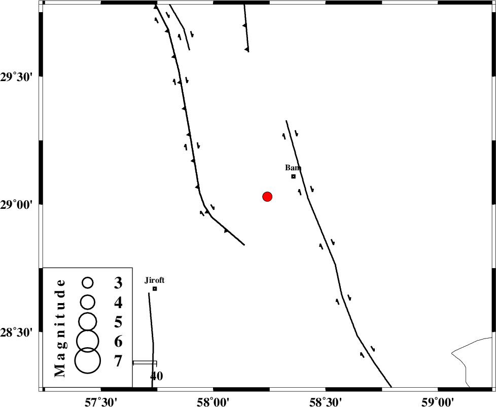
| Location | Lat:29.03 Lon: 58.24 |
| Region | Kerman Province, 14 km West of Bam |
Nearest Cities |
|
| 14 km West of Bam, Kerman Province | |
| 16 km West of Baravat, Kerman Province | |
| 19 km West of Poshtrud, Kerman Province | |
| 31 km North West of Kruk, Kerman Province | |
| 34 km North East of Mohammadabad, Kerman Province | |
| Depth | 17 km |
| Agency | |
Faults within 150 km: |
|
| BAM_F (Length: 118 km) , Distance to epicenter: 18 km | |
| GOWK_F (Length: 152 km) , Distance to epicenter: 23 km | |
| SHAHDAD_F (Length: 108 km) , Distance to epicenter: 63 km | |
| Number of Phases | 5 |
| RMS | 0 |
| Number of Stations | 4 |
| Error in Latitude | >2.5 km |
| Error in Longitude | 2.4 km |
| Error in Depth | 6.1 km |
Download waveform in seisan format
to download seisan software Click here
to access information about IIEES stations Click here
Amplitude | ||||||||
| UID | Agency | Station | Component | Amplitude | Period | Arrival Time | Proccessing Time | Signal Clip |
| 83425 | IIEES | KRBR | E | 196.5 | 0.14 | 2012-05-09 07:24:19 | 2012-05-09 10:00:00 | n |
| 83426 | IIEES | BNDS | N | 28.3 | 0.55 | 2012-05-09 07:24:47 | 2012-05-09 10:00:00 | n |
| 83427 | IIEES | TABS | E | 4.7 | 0.74 | 2012-05-09 07:25:56 | 2012-05-09 10:00:00 | n |
Phase | ||||||||||||
| Agency | Station | Component | Phase Type | Phase Quality | First Motion | Observed Arrival Time | Time Residual | Loc. Flag | Input Weight | Distance | Azimuth | |
| IIEES | KRBR | Z | Pg | E | 2012-05-09 07:23:55 | 0.06 | y | 178 | 307 | |||
| IIEES | KRBR | N | Sg | E | 2012-05-09 07:24:17 | -0.06 | y | 178 | 307 | |||
| IIEES | ZHSF | Z | Pn | E | 2012-05-09 07:24:05 | -0.04 | y | 254 | 75 | |||
| IIEES | BNDS | Z | Pn | E | 2012-05-09 07:24:07 | 0 | y | 272 | 229 | |||
| IIEES | TABS | Z | P | E | 2012-05-09 07:24:38 | 0.06 | y | 523 | 348 | |||