
Magnitude |
3.7 |
| Date & Time (UTC) | 2012-05-29 12:33:24.3 |
| Date & Time (Local) | 1391/3/9 17:03:24.3 |
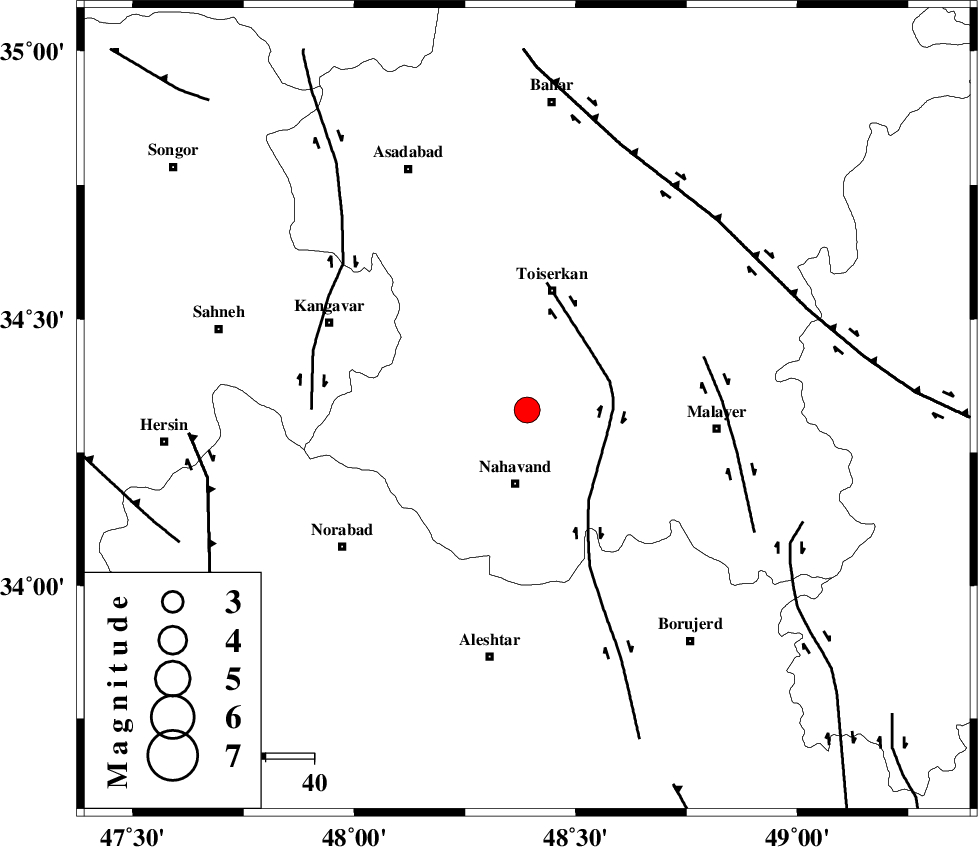
| Location | Lat:34.33 Lon: 48.39 |
| Region | Hamedan Province, 16 km North of Nahavand |
Nearest Cities |
|
| 7 km of Miyandeh, Hamedan Province | |
| 12 km North of Dehghul, Hamedan Province | |
| 12 km North of Avarzman, Hamedan Province | |
| 16 km North of Nahavand, Hamedan Province | |
| 17 km North East of Barzul, Hamedan Province | |
| Depth | 14 km |
| Agency | |
Faults within 150 km: |
|
| NAHAVAND_F (Length: 102 km) , Distance to epicenter: 12 km | |
| SAHANEH_F (Length: 77 km) , Distance to epicenter: 22 km | |
| DINEHVAR_F (Length: 46 km) , Distance to epicenter: 56 km | |
| Number of Phases | 5 |
| RMS | 0.1 |
| Number of Stations | 5 |
| Error in Latitude | >3.1 km |
| Error in Longitude | 2.4 km |
| Error in Depth | 5 km |
Download waveform in seisan format
to download seisan software Click here
to access information about IIEES stations Click here
Amplitude | ||||||||
| UID | Agency | Station | Component | Amplitude | Period | Arrival Time | Proccessing Time | Signal Clip |
| 83796 | IIEES | SHGR | N | 609.3 | 0.48 | 2012-05-29 12:34:37 | 2012-05-29 12:57:00 | n |
| 83797 | IIEES | SHGR | E | 478.4 | 0.64 | 2012-05-29 12:34:37 | 2012-05-29 12:57:00 | n |
| 83798 | IIEES | GHVR | N | 319.4 | 0.52 | 2012-05-29 12:34:43 | 2012-05-29 12:57:00 | n |
| 83799 | IIEES | GHVR | E | 356 | 0.48 | 2012-05-29 12:34:43 | 2012-05-29 12:57:00 | n |
Phase | ||||||||||||
| Agency | Station | Component | Phase Type | Phase Quality | First Motion | Observed Arrival Time | Time Residual | Loc. Flag | Input Weight | Distance | Azimuth | |
| IIEES | SNGE | Z | Pg | E | 2012-05-29 12:33:45 | 0.01 | y | 127 | 312 | |||
| IIEES | ASAO | Z | Pg | E | 2012-05-29 12:33:49 | -0.19 | y | 152 | 80 | |||
| IIEES | SHGR | Z | Pn | E | 2012-05-29 12:34:02 | -0.04 | y | 250 | 171 | |||
| IIEES | GHVR | Z | Pn | E | 2012-05-29 12:34:04 | 0.14 | y | 263 | 86 | |||
| IIEES | DAMV | Z | Pn | E | 2012-05-29 12:34:16 | 0.1 | y | 358 | 65 | |||