
Magnitude |
1.7 |
| Date & Time (UTC) | 2012-05-31 20:41:33.3 |
| Date & Time (Local) | 1391/3/12 01:11:33.3 |
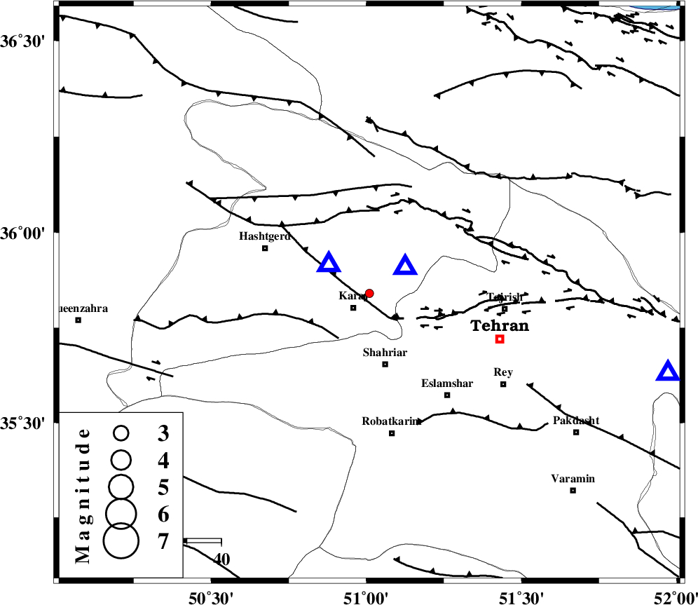
| Location | Lat:35.84 Lon: 51.01 |
| Region | Tehran Province, 7 km Karaj |
Nearest Cities |
|
| 6 km North of Karaj, Tehran Province | |
| 11 km of Barghan, Tehran Province | |
| 20 km North of Malard, Tehran Province | |
| 21 km North of Shahriyar, Tehran Province | |
| 21 km South East of Chandar, Tehran Province | |
| Depth | 14 km |
| Agency | |
Faults within 150 km: |
|
| N_TEHRAN_F4 (Length: 115 km) , Distance to epicenter: 8 km | |
| ESHTEHARD_F (Length: 69 km) , Distance to epicenter: 16 km | |
| MOSHA_F (Length: 234 km) , Distance to epicenter: 24 km | |
| Number of Phases | 5 |
| RMS | 0.1 |
| Number of Stations | 4 |
| Error in Latitude | >2.4 km |
| Error in Longitude | 2.8 km |
| Error in Depth | 6.3 km |
Download waveform in seisan format
to download seisan software Click here
to access information about IIEES stations Click here
Amplitude | ||||||||
| UID | Agency | Station | Component | Amplitude | Period | Arrival Time | Proccessing Time | Signal Clip |
| 83835 | IIEES | CHTH | E | 769.2 | 0.07 | 2012-05-31 20:41:39 | 2012-06-01 01:36:00 | n |
| 83836 | IIEES | DAMV | N | 7.4 | 0.16 | 2012-05-31 20:42:04 | 2012-06-01 01:36:00 | n |
| 83837 | IIEES | GHVR | N | 12.9 | 0.2 | 2012-05-31 20:42:18 | 2012-06-01 01:36:00 | n |
| 83838 | IIEES | GHVR | E | 15.9 | 0.45 | 2012-05-31 20:42:23 | 2012-06-01 01:36:00 | n |
Phase | ||||||||||||
| Agency | Station | Component | Phase Type | Phase Quality | First Motion | Observed Arrival Time | Time Residual | Loc. Flag | Input Weight | Distance | Azimuth | |
| IIEES | CHTH | Z | Pg | E | 2012-05-31 20:41:36 | -0.06 | y | 12.6 | 53 | |||
| IIEES | THKV | Z | Pg | E | 2012-05-31 20:41:37 | -0.01 | y | 14.8 | 305 | |||
| IIEES | DAMV | Z | Pg | E | 2012-05-31 20:41:48 | 0.03 | y | 89.6 | 105 | |||
| IIEES | GHVR | Z | Pg | E | 2012-05-31 20:41:58 | 0.13 | y | 152 | 172 | |||
| IIEES | GHVR | E | Sg | E | 2012-05-31 20:42:17 | -0.1 | y | 152 | 172 | |||