
Magnitude |
2.3 |
| Date & Time (UTC) | 2012-07-31 23:37:00.5 |
| Date & Time (Local) | 1391/5/11 04:07:00.5 |
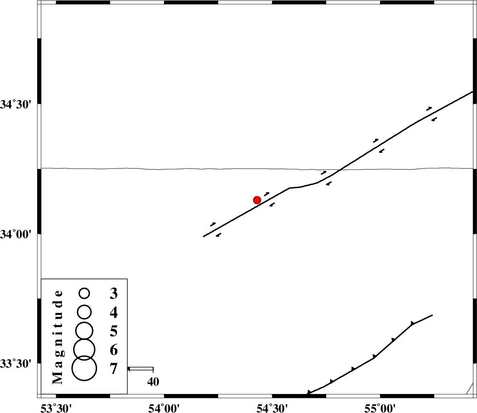
| Location | Lat:34.13 Lon: 54.43 |
| Region | Esfahan Province, 227 km South of Damghan |
Nearest Cities |
|
| 10 km North of Jondaq, Esfahan Province | |
| 57 km North West of Farrokhi, Esfahan Province | |
| 57 km North of Chupanan, Esfahan Province | |
| 72 km North West of Khur, Esfahan Province | |
| 97 km North West of Mehranjan, Esfahan Province | |
| Depth | 14 km |
| Agency | |
Faults within 150 km: |
|
| DORUNEH_F (Length: 713 km) , Distance to epicenter: 15 km | |
| BIABANAK_F (Length: 162 km) , Distance to epicenter: 84 km | |
| TORUD_F (Length: 136 km) , Distance to epicenter: 123 km | |
| Number of Phases | 4 |
| RMS | 0 |
| Number of Stations | 3 |
| Error in Latitude | >2.7 km |
| Error in Longitude | 2 km |
| Error in Depth | 5.7 km |
Download waveform in seisan format
to download seisan software Click here
to access information about IIEES stations Click here
Amplitude | ||||||||
| UID | Agency | Station | Component | Amplitude | Period | Arrival Time | Proccessing Time | Signal Clip |
| 84694 | IIEES | YZKH | N | 24.5 | 0.68 | 2012-07-31 23:37:59 | 2012-08-01 02:55:00 | n |
| 84695 | IIEES | GHVR | N | 14.7 | 0.36 | 2012-07-31 23:38:32 | 2012-08-01 02:55:00 | n |
| 84696 | IIEES | GHVR | E | 15.3 | 0.44 | 2012-07-31 23:38:36 | 2012-08-01 02:55:00 | n |
Phase | ||||||||||||
| Agency | Station | Component | Phase Type | Phase Quality | First Motion | Observed Arrival Time | Time Residual | Loc. Flag | Input Weight | Distance | Azimuth | |
| IIEES | YZKH | Z | Pg | E | 2012-07-31 23:37:32 | 0 | y | 193 | 176 | |||
| IIEES | SHRO | Z | Pn | E | 2012-07-31 23:37:39 | 0 | y | 254 | 34 | |||
| IIEES | GHVR | Z | Pn | E | 2012-07-31 23:37:44 | 0 | y | 296 | 278 | |||
| IIEES | GHVR | E | Sg | E | 2012-07-31 23:38:23 | 0 | y | 296 | 278 | |||