
Magnitude |
3.4 |
| Date & Time (UTC) | 2012-08-16 02:29:40.0 |
| Date & Time (Local) | 1391/5/26 06:59:40.0 |
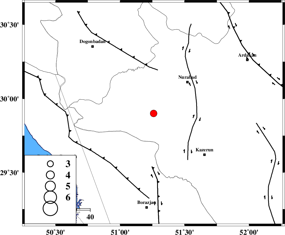
| Location | Lat:29.9 Lon: 51.26 |
| Region | Fars Province, 35 km South-West of Nurabad |
Nearest Cities |
|
| 19 km South of Babamonir, Fars Province | |
| 29 km South West of Ahangari, Fars Province | |
| 33 km South West of Gachgaran, Fars Province | |
| 35 km South West of Nurabad, Fars Province | |
| 37 km North West of Kamaraj, Fars Province | |
| Depth | 16 km |
| Agency | |
Faults within 150 km: |
|
| KAZERUN_F (Length: 96 km) , Distance to epicenter: 31 km | |
| MISHAN_F (Length: 76 km) , Distance to epicenter: 33 km | |
| BORAZJAN_F (Length: 168 km) , Distance to epicenter: 40 km | |
| Number of Phases | 6 |
| RMS | 0.1 |
| Number of Stations | 6 |
| Error in Latitude | >2.1 km |
| Error in Longitude | 1.7 km |
| Error in Depth | 0 km |
Download waveform in seisan format
to download seisan software Click here
to access information about IIEES stations Click here
Amplitude | ||||||||
| UID | Agency | Station | Component | Amplitude | Period | Arrival Time | Proccessing Time | Signal Clip |
| 85395 | IIEES | GHIR | E | 246.7 | 0.64 | 2012-08-16 02:30:59 | 2012-08-16 03:46:00 | n |
| 85396 | IIEES | GHIR | N | 202.9 | 0.48 | 2012-08-16 02:30:59 | 2012-08-16 03:46:00 | n |
Phase | ||||||||||||
| Agency | Station | Component | Phase Type | Phase Quality | First Motion | Observed Arrival Time | Time Residual | Loc. Flag | Input Weight | Distance | Azimuth | |
| IIEES | GHIR | Z | Pn | E | 2012-08-16 02:30:18 | 0.02 | y | 246 | 136 | |||
| IIEES | NASN | Z | Pn | E | 2012-08-16 02:30:31 | 0.1 | y | 354 | 24 | |||
| IIEES | YZKH | Z | Pn | E | 2012-08-16 02:30:39 | -0.13 | y | 421 | 48 | |||
| IIEES | KHMZ | Z | Pn | E | 2012-08-16 02:30:42 | 0.13 | y | 443 | 344 | |||
| IIEES | SNGE | Z | Pn | E | 2012-08-16 02:31:12 | -0.22 | y | 683 | 328 | |||
| IIEES | TABS | Z | Pn | E | 2012-08-16 02:31:13 | -0.02 | y | 693 | 52 | |||