
Magnitude |
3.7 |
| Date & Time (UTC) | 2012-10-21 19:07:50.1 |
| Date & Time (Local) | 1391/7/30 22:37:50.1 |
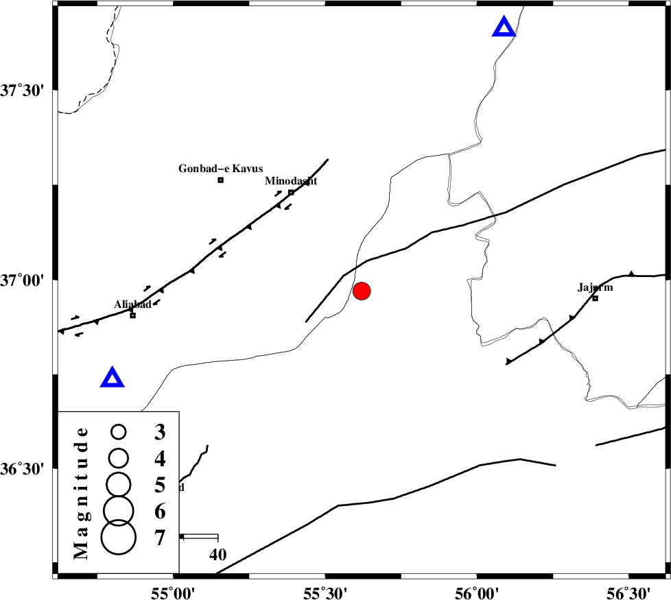
| Location | Lat:36.97 Lon: 55.62 |
| Region | Semnan Province, 36 km South-East of Minodasht |
Nearest Cities |
|
| 3 km of Qaleh qafeh, Semnan Province | |
| 14 km East of Qale-ye qafeh, Golestan Province | |
| 16 km West of Nardin, Semnan Province | |
| 17 km South of Rezvan, Semnan Province | |
| 17 km South of Duzin, Golestan Province | |
| Depth | 6 km |
| Agency | |
Faults within 150 km: |
|
| ROBATE_QARABIL_F (Length: 168 km) , Distance to epicenter: 7 km | |
| SHAVAR_F (Length: 87 km) , Distance to epicenter: 42 km | |
| JAJARAM_F (Length: 77 km) , Distance to epicenter: 47 km | |
| Number of Phases | 8 |
| RMS | 0.1 |
| Number of Stations | 6 |
| Error in Latitude | >1 km |
| Error in Longitude | 2.9 km |
| Error in Depth | 4.5 km |
Download waveform in seisan format
to download seisan software Click here
to access information about IIEES stations Click here
Amplitude | ||||||||
| UID | Agency | Station | Component | Amplitude | Period | Arrival Time | Proccessing Time | Signal Clip |
| 86707 | IIEES | TABS | N | 164.2 | 0.68 | 2012-10-21 19:09:57 | 2012-10-21 07:32:00 | n |
| 86708 | IIEES | GHVR | N | 84.4 | 0.56 | 2012-10-21 19:10:22 | 2012-10-21 07:32:00 | n |
| 86709 | IIEES | GHVR | E | 86.4 | 0.56 | 2012-10-21 19:10:26 | 2012-10-21 07:32:00 | n |
Phase | ||||||||||||
| Agency | Station | Component | Phase Type | Phase Quality | First Motion | Observed Arrival Time | Time Residual | Loc. Flag | Input Weight | Distance | Azimuth | |
| IIEES | MRVT | Z | Pg | E | 2012-10-21 19:08:05 | -0.15 | y | 87.7 | 28 | |||
| IIEES | MRVT | E | Sg | E | 2012-10-21 19:08:16 | -0.1 | y | 87.7 | 28 | |||
| IIEES | SHRO | Z | Pg | E | 2012-10-21 19:08:09 | -0.14 | y | 112 | 161 | |||
| IIEES | SHRO | E | Sg | E | 2012-10-21 19:08:23 | -0.05 | y | 112 | 161 | |||
| IIEES | BJRD | Z | Pg | E | 2012-10-21 19:08:20 | 0 | y | 178 | 62 | |||
| IIEES | BJRD | E | Sg | E | 2012-10-21 19:08:43 | 0.2 | y | 178 | 62 | |||
| IIEES | DAMV | Z | Pn | E | 2012-10-21 19:08:43 | 0.19 | y | 360 | 247 | |||
| IIEES | TABS | Z | Pn | E | 2012-10-21 19:08:47 | 0.1 | y | 392 | 159 | |||