
Magnitude |
2.8 |
| Date & Time (UTC) | 2012-11-18 07:45:10.7 |
| Date & Time (Local) | 1391/8/28 11:15:10.7 |
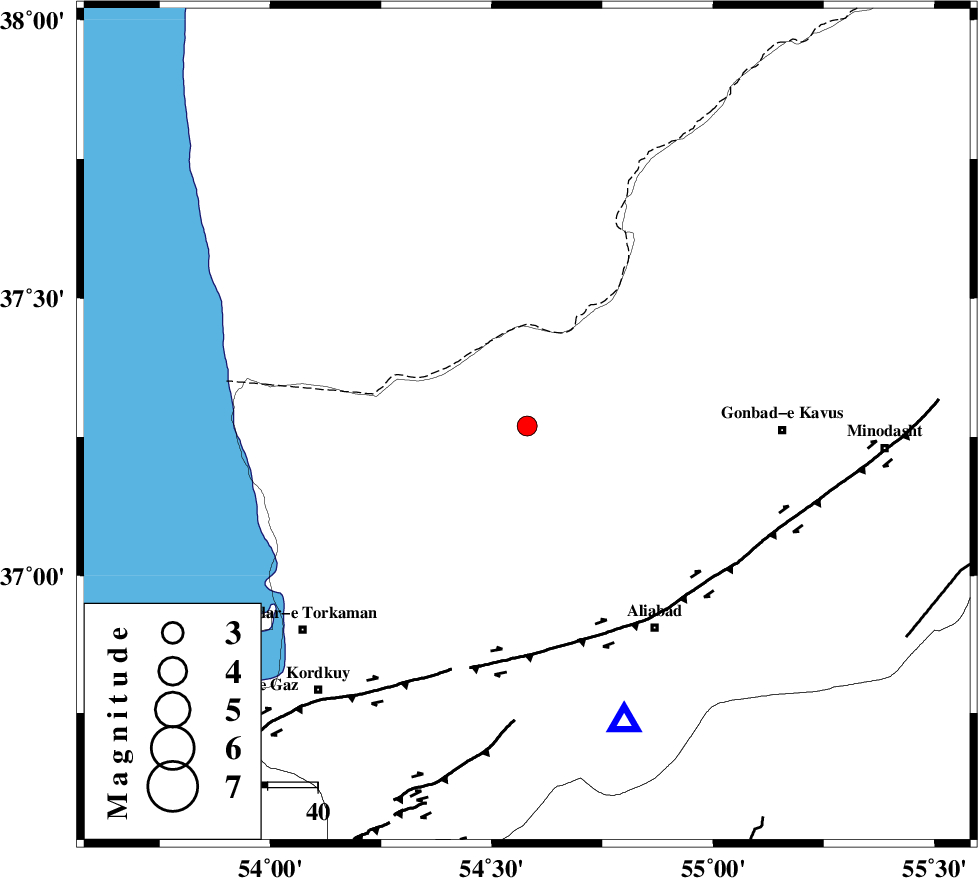
| Location | Lat:37.27 Lon: 54.58 |
| Region | Golestan Province, 30 km North-East of Aq Qaleh |
Nearest Cities |
|
| 24 km South West of Enchehborun, Golestan Province | |
| 25 km North West of Gariduji, Golestan Province | |
| 29 km North of Qanqarmeh, Golestan Province | |
| 31 km North East of Aq Qaleh, Golestan Province | |
| 33 km North of Nodeh malek, Golestan Province | |
| Depth | 14 km |
| Agency | |
Faults within 150 km: |
|
| KHAZAR_F (Length: 523 km) , Distance to epicenter: 45 km | |
| N_ALBORZ_F (Length: 360 km) , Distance to epicenter: 75 km | |
| SHAVAR_F (Length: 87 km) , Distance to epicenter: 77 km | |
| Number of Phases | 7 |
| RMS | 0.2 |
| Number of Stations | 6 |
| Error in Latitude | >4 km |
| Error in Longitude | 3.8 km |
| Error in Depth | 6.6 km |
Download waveform in seisan format
to download seisan software Click here
to access information about IIEES stations Click here
Amplitude | ||||||||
| UID | Agency | Station | Component | Amplitude | Period | Arrival Time | Proccessing Time | Signal Clip |
| 87075 | IIEES | THKV | E | 20.8 | 0.44 | 2012-11-18 07:47:04 | 2012-11-18 08:53:00 | n |
Phase | ||||||||||||
| Agency | Station | Component | Phase Type | Phase Quality | First Motion | Observed Arrival Time | Time Residual | Loc. Flag | Input Weight | Distance | Azimuth | |
| IIEES | MRVT | Z | Pg | E | 2012-11-18 07:45:34 | 0.21 | y | 141 | 71 | |||
| IIEES | MRVT | E | Sg | E | 2012-11-18 07:45:51 | -0.22 | y | 141 | 71 | |||
| IIEES | SHRO | Z | Pg | E | 2012-11-18 07:45:41 | 0 | y | 190 | 137 | |||
| IIEES | BJRD | Z | Pn | E | 2012-11-18 07:45:50 | 0.13 | y | 255 | 78 | |||
| IIEES | DAMV | Z | Pn | E | 2012-11-18 07:45:55 | 0.01 | y | 296 | 233 | |||
| IIEES | CHTH | Z | Pn | E | 2012-11-18 07:46:01 | 0.08 | y | 343 | 245 | |||
| IIEES | THKV | Z | Pn | E | 2012-11-18 07:46:03 | -0.23 | y | 363 | 247 | |||