
Magnitude |
3.2 |
| Date & Time (UTC) | 2012-12-12 02:13:30.5 |
| Date & Time (Local) | 1391/9/22 05:43:30.5 |
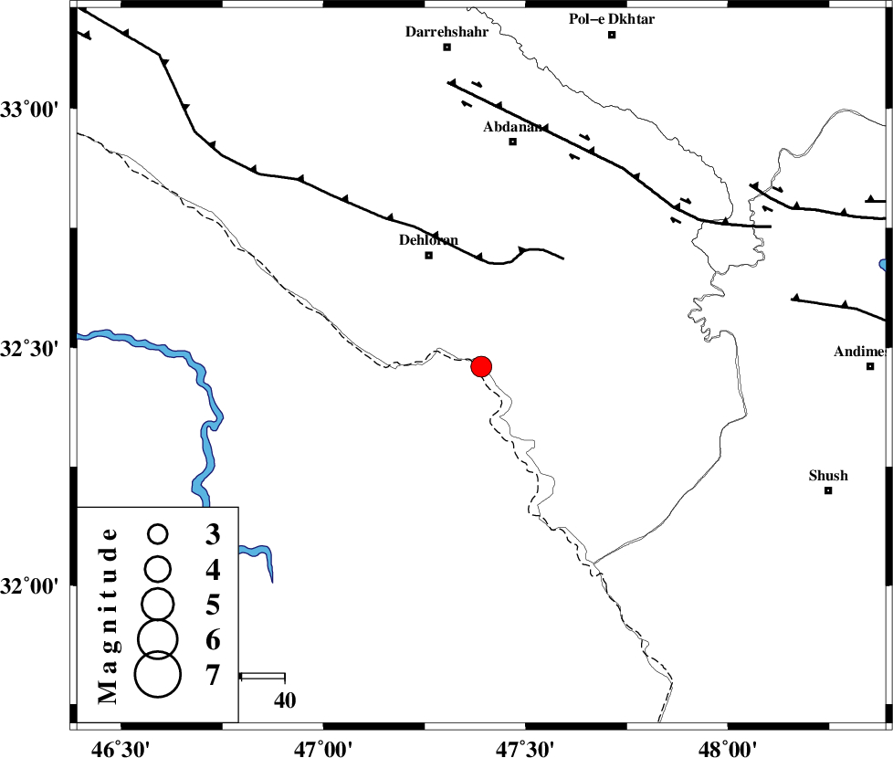
| Location | Lat:32.46 Lon: 47.39 |
| Region | 28 km South-East of Dehloran |
Nearest Cities |
|
| 10 km of Musian, Ilam Province | |
| 29 km South East of Dehloran, Ilam Province | |
| 51 km South West of Sarabbagh, Ilam Province | |
| 53 km South of Abdanan, Ilam Province | |
| 56 km South East of Bishehzar, Ilam Province | |
| Depth | 36 km |
| Agency | |
Faults within 150 km: |
|
| MFF6 (Length: 144 km) , Distance to epicenter: 24 km | |
| BALARUD_F_Z1 (Length: 87 km) , Distance to epicenter: 57 km | |
| DEZFUL_EMBAYMENT (Length: 228 km) , Distance to epicenter: 73 km | |
| Number of Phases | 5 |
| RMS | 0.2 |
| Number of Stations | 3 |
| Error in Latitude | >3.9 km |
| Error in Longitude | 9.5 km |
| Error in Depth | 9.3 km |
Download waveform in seisan format
to download seisan software Click here
to access information about IIEES stations Click here
Amplitude | ||||||||
| UID | Agency | Station | Component | Amplitude | Period | Arrival Time | Proccessing Time | Signal Clip |
| 87314 | IIEES | SHGR | E | 1045.9 | 0.88 | 2012-12-12 02:14:15 | 2012-12-12 02:50:00 | n |
| 87315 | IIEES | SHGR | N | 508.1 | 0.4 | 2012-12-12 02:14:20 | 2012-12-12 02:50:00 | n |
| 87316 | IIEES | KHMZ | N | 28 | 0.52 | 2012-12-12 02:15:01 | 2012-12-12 02:50:00 | n |
Phase | ||||||||||||
| Agency | Station | Component | Phase Type | Phase Quality | First Motion | Observed Arrival Time | Time Residual | Loc. Flag | Input Weight | Distance | Azimuth | |
| IIEES | SHGR | Z | Pg | E | 2012-12-12 02:13:53 | 0.01 | y | 139 | 106 | |||
| IIEES | SHGR | N | Sg | E | 2012-12-12 02:14:10 | -0.01 | y | 139 | 106 | |||
| IIEES | KHMZ | Z | Pn | E | 2012-12-12 02:14:11 | 0.27 | y | 279 | 59 | |||
| IIEES | KHMZ | N | Sg | E | 2012-12-12 02:14:47 | 0 | y | 279 | 59 | |||
| IIEES | GHVR | Z | Pn | E | 2012-12-12 02:14:28 | -0.34 | y | 423 | 57 | |||