
Magnitude |
2.8 |
| Date & Time (UTC) | 2012-12-25 08:19:33.6 |
| Date & Time (Local) | 1391/10/5 11:49:33.6 |
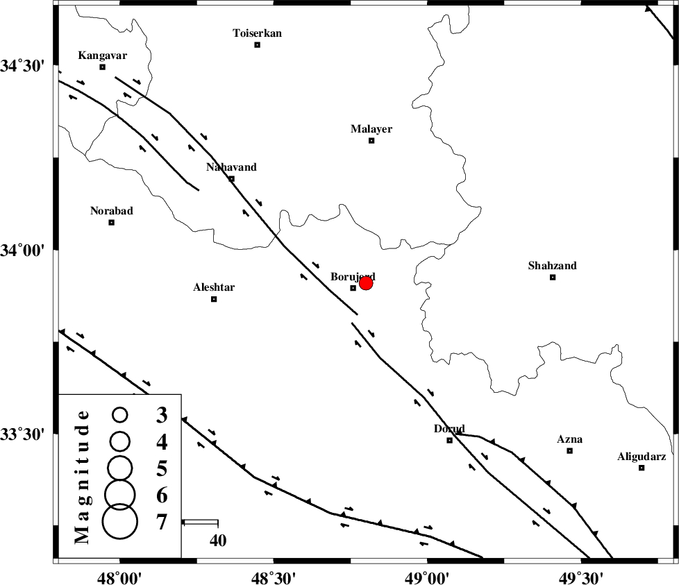
| Location | Lat:33.91 Lon: 48.8 |
| Region | Lorestan Province, 4 km Borujerd |
Nearest Cities |
|
| 4 km North of Borujerd, Lorestan Province | |
| 6 km North of Valanjerd, Lorestan Province | |
| 8 km North of Hemmatabad, Lorestan Province | |
| 14 km East of Bon dizeh, Lorestan Province | |
| 17 km South of Darre-ye gorg, Lorestan Province | |
| Depth | 14 km |
| Agency | |
Faults within 150 km: |
|
| NAHAVAND_F (Length: 102 km) , Distance to epicenter: 10 km | |
| DORUD (Length: 100 km) , Distance to epicenter: 13 km | |
| MAIN_ZAGROS_R_F (Length: 1106 km) , Distance to epicenter: 53 km | |
| Number of Phases | 5 |
| RMS | 0.2 |
| Number of Stations | 5 |
| Error in Latitude | >3.7 km |
| Error in Longitude | 2.7 km |
| Error in Depth | 7 km |
Download waveform in seisan format
to download seisan software Click here
to access information about IIEES stations Click here
Amplitude | ||||||||
| UID | Agency | Station | Component | Amplitude | Period | Arrival Time | Proccessing Time | Signal Clip |
| 87425 | IIEES | KHMZ | N | 247.5 | 0.3 | 2012-12-25 08:20:09 | 2012-12-25 08:48:00 | n |
| 87426 | IIEES | SHGR | E | 117.3 | 0.36 | 2012-12-25 08:20:36 | 2012-12-25 08:48:00 | n |
Phase | ||||||||||||
| Agency | Station | Component | Phase Type | Phase Quality | First Motion | Observed Arrival Time | Time Residual | Loc. Flag | Input Weight | Distance | Azimuth | |
| IIEES | ASAO | Z | Pg | E | 2012-12-25 08:19:55 | -0.31 | y | 134 | 58 | |||
| IIEES | ASAO | E | Sg | E | 2012-12-25 08:20:12 | 0.08 | y | 134 | 58 | |||
| IIEES | SNGE | Z | Pg | E | 2012-12-25 08:20:04 | -0.03 | y | 187 | 315 | |||
| IIEES | SHGR | Z | Pn | E | 2012-12-25 08:20:05 | 0.03 | y | 199 | 180 | |||
| IIEES | CHTH | Z | Pn | E | 2012-12-25 08:20:19 | 0.26 | y | 308 | 43 | |||