
Magnitude |
2.9 |
| Date & Time (UTC) | 2012-12-26 07:16:30.1 |
| Date & Time (Local) | 1391/10/6 10:46:30.1 |
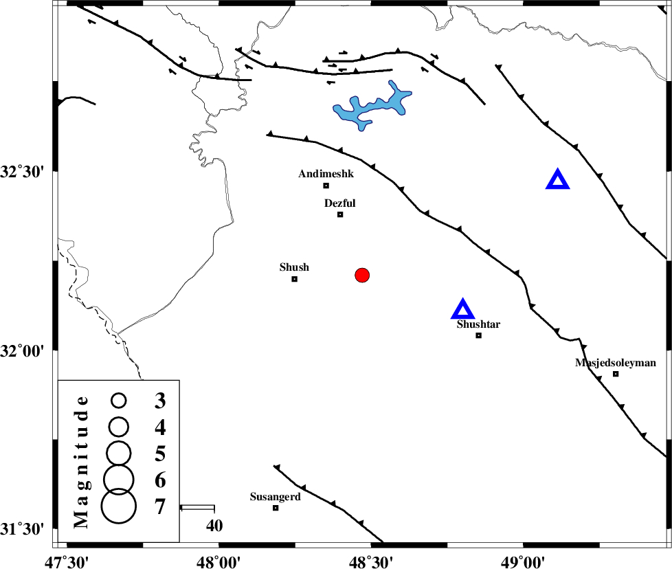
| Location | Lat:32.21 Lon: 48.47 |
| Region | Khoozestan Province, 21 km East of Shush |
Nearest Cities |
|
| 10 km of Shamsabad, Khoozestan Province | |
| 18 km North East of Amaleh teimur, Khoozestan Province | |
| 20 km South of Dezful, Khoozestan Province | |
| 21 km North East of Shush, Khoozestan Province | |
| 27 km South West of Mahur berenji, Khoozestan Province | |
| Depth | 14 km |
| Agency | |
Faults within 150 km: |
|
| DEZFUL_EMBAYMENT (Length: 228 km) , Distance to epicenter: 27 km | |
| BALARUD_F_Z3 (Length: 53 km) , Distance to epicenter: 63 km | |
| BALARUD_F_Z2 (Length: 58 km) , Distance to epicenter: 65 km | |
| Number of Phases | 7 |
| RMS | 0.3 |
| Number of Stations | 5 |
| Error in Latitude | >3.3 km |
| Error in Longitude | 7.8 km |
| Error in Depth | 9.8 km |
Download waveform in seisan format
to download seisan software Click here
to access information about IIEES stations Click here
Amplitude | ||||||||
| UID | Agency | Station | Component | Amplitude | Period | Arrival Time | Proccessing Time | Signal Clip |
| 87444 | IIEES | SHGR | N | 1342.3 | 0.33 | 2012-12-26 07:16:48 | 2012-12-26 08:01:00 | n |
| 87445 | IIEES | SHGR | E | 1492.5 | 0.66 | 2012-12-26 07:16:50 | 2012-12-26 08:01:00 | n |
Phase | ||||||||||||
| Agency | Station | Component | Phase Type | Phase Quality | First Motion | Observed Arrival Time | Time Residual | Loc. Flag | Input Weight | Distance | Azimuth | |
| IIEES | SHGR | Z | Pg | E | 2012-12-26 07:16:35 | -0.55 | y | 33.2 | 110 | |||
| IIEES | SHGR | N | Sg | E | 2012-12-26 07:16:41 | 0.32 | y | 33.2 | 110 | |||
| IIEES | ASAO | Z | Pn | E | 2012-12-26 07:17:15 | 0.19 | y | 297 | 29 | |||
| IIEES | ASAO | E | Sg | E | 2012-12-26 07:17:53 | -0.15 | y | 297 | 29 | |||
| IIEES | SNGE | Z | Pn | E | 2012-12-26 07:17:19 | 0.08 | y | 336 | 342 | |||
| IIEES | ZNJK | Z | Pn | E | 2012-12-26 07:17:39 | 0.07 | y | 495 | 2 | |||
| IIEES | YZKH | Z | Pn | E | 2012-12-26 07:17:49 | 0.13 | y | 577 | 86 | |||