
Magnitude |
3.6 |
| Date & Time (UTC) | 2013-01-07 13:18:19.8 |
| Date & Time (Local) | 1391/10/18 16:48:19.8 |
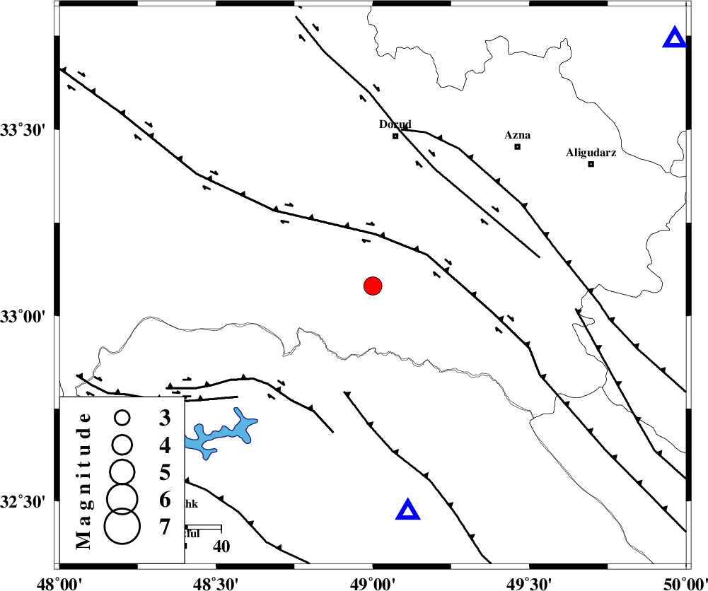
| Location | Lat:33.08 Lon: 49 |
| Region | Lorestan Province, 45 km South of Dorud |
Nearest Cities |
|
| 7 km North of Bargsar, Lorestan Province | |
| 20 km South West of Shulabad, Lorestan Province | |
| 21 km South East of Chamsangar, Lorestan Province | |
| 21 km South of Sartang barzeh, Lorestan Province | |
| 36 km North East of Shuy, Khoozestan Province | |
| Depth | 14 km |
| Agency | |
Faults within 150 km: |
|
| HZF4 (Length: 492 km) , Distance to epicenter: 15 km | |
| MFF2 (Length: 205 km) , Distance to epicenter: 33 km | |
| DORUD (Length: 100 km) , Distance to epicenter: 39 km | |
| Number of Phases | 5 |
| RMS | 0.2 |
| Number of Stations | 4 |
| Error in Latitude | >2.2 km |
| Error in Longitude | 3.5 km |
| Error in Depth | 7.5 km |
Download waveform in seisan format
to download seisan software Click here
to access information about IIEES stations Click here
Amplitude | ||||||||
| UID | Agency | Station | Component | Amplitude | Period | Arrival Time | Proccessing Time | Signal Clip |
| 87543 | IIEES | SHGR | N | 1696.5 | 0.36 | 2013-01-07 13:18:58 | 2013-01-07 01:50:00 | n |
| 87544 | IIEES | SHGR | E | 1465.9 | 0.4 | 2013-01-07 13:19:01 | 2013-01-07 01:50:00 | n |
Phase | ||||||||||||
| Agency | Station | Component | Phase Type | Phase Quality | First Motion | Observed Arrival Time | Time Residual | Loc. Flag | Input Weight | Distance | Azimuth | |
| IIEES | SHGR | Z | Pg | E | 2013-01-07 13:18:38 | -0.11 | y | 110 | 190 | |||
| IIEES | KHMZ | Z | Pg | E | 2013-01-07 13:18:39 | 0.1 | y | 115 | 51 | |||
| IIEES | ASAO | Z | Pg | E | 2013-01-07 13:18:50 | -0.19 | y | 188 | 30 | |||
| IIEES | SNGE | Z | Pn | E | 2013-01-07 13:19:01 | 0.4 | y | 270 | 326 | |||
| IIEES | SNGE | E | Sg | E | 2013-01-07 13:19:35 | -0.18 | y | 270 | 326 | |||