
Magnitude |
3 |
| Date & Time (UTC) | 2013-01-13 09:07:45.6 |
| Date & Time (Local) | 1391/10/24 12:37:45.6 |
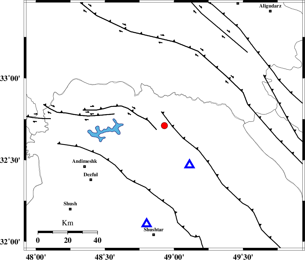
| Location | Lat:32.71 Lon: 48.93 |
| Region | Khoozestan Province, 39 km North-West of Lali |
Nearest Cities |
|
| 15 km East of Shuy, Khoozestan Province | |
| 25 km North of Sardasht, Khoozestan Province | |
| 37 km South of Bargsar, Lorestan Province | |
| 39 km North West of Lali, Khoozestan Province | |
| 43 km North East of Mahur berenji, Khoozestan Province | |
| Depth | 14 km |
| Agency | |
Faults within 150 km: |
|
| MFF2 (Length: 205 km) , Distance to epicenter: 5 km | |
| BALARUD_F_Z2 (Length: 58 km) , Distance to epicenter: 6 km | |
| BALARUD_F_Z3 (Length: 53 km) , Distance to epicenter: 35 km | |
| Number of Phases | 6 |
| RMS | 0.3 |
| Number of Stations | 5 |
| Error in Latitude | >4.9 km |
| Error in Longitude | 9.1 km |
| Error in Depth | 9.5 km |
Download waveform in seisan format
to download seisan software Click here
to access information about IIEES stations Click here
Amplitude | ||||||||
| UID | Agency | Station | Component | Amplitude | Period | Arrival Time | Proccessing Time | Signal Clip |
| 87612 | IIEES | SHGR | N | 632 | 0.63 | 2013-01-13 09:08:24 | 2013-01-13 09:32:00 | n |
| 87613 | IIEES | SHGR | E | 813.9 | 0.59 | 2013-01-13 09:08:27 | 2013-01-13 09:32:00 | n |
| 87614 | IIEES | KHMZ | N | 274.8 | 0.49 | 2013-01-13 09:08:35 | 2013-01-13 09:32:00 | n |
Phase | ||||||||||||
| Agency | Station | Component | Phase Type | Phase Quality | First Motion | Observed Arrival Time | Time Residual | Loc. Flag | Input Weight | Distance | Azimuth | |
| IIEES | SHGR | Z | Pg | E | 2013-01-13 09:07:57 | 0.03 | y | 67.6 | 191 | |||
| IIEES | KHMZ | Z | Pg | E | 2013-01-13 09:08:10 | -0.38 | y | 149 | 40 | |||
| IIEES | KHMZ | E | Sg | E | 2013-01-13 09:08:28 | 0.12 | y | 149 | 40 | |||
| IIEES | ASAO | Z | Pn | E | 2013-01-13 09:08:22 | 0.46 | y | 228 | 26 | |||
| IIEES | SNGE | Z | Pn | E | 2013-01-13 09:08:31 | -0.07 | y | 303 | 331 | |||
| IIEES | CHTH | Z | Pn | E | 2013-01-13 09:08:44 | -0.22 | y | 408 | 29 | |||