
Magnitude |
2.6 |
| Date & Time (UTC) | 2013-01-14 01:32:01.7 |
| Date & Time (Local) | 1391/10/25 05:02:01.7 |
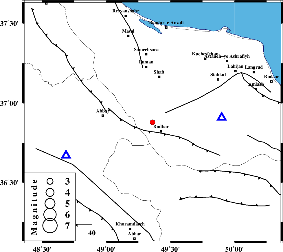
| Location | Lat:36.88 Lon: 49.36 |
| Region | Gilan Province, 9 km Rudbar |
Nearest Cities |
|
| 9 km North of Rudbar, Gilan Province | |
| 10 km North West of Rostamabad, Gilan Province | |
| 16 km North of Manjil, Gilan Province | |
| 17 km West of Nasir mahalleh, Gilan Province | |
| 21 km North of Siyahpush, Ghazvin Province | |
| Depth | 18 km |
| Agency | |
Faults within 150 km: |
|
| RUDBAR_F (Length: 93 km) , Distance to epicenter: 8 km | |
| LAHIJAN_F (Length: 92 km) , Distance to epicenter: 11 km | |
| MASULEL_F (Length: 90 km) , Distance to epicenter: 32 km | |
| Number of Phases | 6 |
| RMS | 0 |
| Number of Stations | 5 |
| Error in Latitude | >1.5 km |
| Error in Longitude | 1.7 km |
| Error in Depth | 2.6 km |
Download waveform in seisan format
to download seisan software Click here
to access information about IIEES stations Click here
Amplitude | ||||||||
| UID | Agency | Station | Component | Amplitude | Period | Arrival Time | Proccessing Time | Signal Clip |
| 87616 | IIEES | GHVR | E | 20.6 | 0.68 | 2013-01-14 01:33:30 | 2013-01-14 03:11:00 | n |
Phase | ||||||||||||
| Agency | Station | Component | Phase Type | Phase Quality | First Motion | Observed Arrival Time | Time Residual | Loc. Flag | Input Weight | Distance | Azimuth | |
| IIEES | ZNJK | Z | Pg | E | 2013-01-14 01:32:13 | 0.01 | y | 64.8 | 249 | |||
| IIEES | THKV | Z | Pg | E | 2013-01-14 01:32:30 | -0.05 | y | 173 | 128 | |||
| IIEES | CHTH | Z | Pn | E | 2013-01-14 01:32:33 | -0.05 | y | 192 | 124 | |||
| IIEES | CHTH | E | Sg | E | 2013-01-14 01:32:56 | 0.06 | y | 192 | 124 | |||
| IIEES | GRMI | Z | Pn | E | 2013-01-14 01:32:40 | 0.05 | y | 250 | 329 | |||
| IIEES | GRMI | E | Sg | E | 2013-01-14 01:33:12 | -0.02 | y | 250 | 329 | |||