
Magnitude |
3.2 |
| Date & Time (UTC) | 2013-01-18 01:12:47.4 |
| Date & Time (Local) | 1391/10/29 04:42:47.4 |
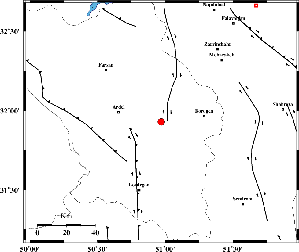
| Location | Lat:31.93 Lon: 50.97 |
| Region | Chaharmahal Bakhtiari Province, 31 km West of Borujen |
Nearest Cities |
|
| 8 km North of Baladaji, Chaharmahal Bakhtiari Province | |
| 19 km North West of Gandoman, Chaharmahal Bakhtiari Province | |
| 20 km South East of Shalamzar, Chaharmahal Bakhtiari Province | |
| 22 km East of Naghan, Chaharmahal Bakhtiari Province | |
| 22 km West of Faradonbeh, Chaharmahal Bakhtiari Province | |
| Depth | 46 km |
| Agency | |
Faults within 150 km: |
|
| DENA_F (Length: 137 km) , Distance to epicenter: 6 km | |
| ARDAL_F (Length: 170 km) , Distance to epicenter: 9 km | |
| MAIN_ZAGROS_R_F (Length: 1106 km) , Distance to epicenter: 13 km | |
| Number of Phases | 8 |
| RMS | 0.2 |
| Number of Stations | 5 |
| Error in Latitude | >3.2 km |
| Error in Longitude | 3.7 km |
| Error in Depth | 5.8 km |
Download waveform in seisan format
to download seisan software Click here
to access information about IIEES stations Click here
Amplitude | ||||||||
| UID | Agency | Station | Component | Amplitude | Period | Arrival Time | Proccessing Time | Signal Clip |
| 87644 | IIEES | SHGR | N | 264.4 | 0.64 | 2013-01-18 01:13:56 | 2013-01-18 01:43:00 | n |
| 87645 | IIEES | SHGR | E | 179.6 | 0.56 | 2013-01-18 01:13:57 | 2013-01-18 01:43:00 | n |
| 87646 | IIEES | KHMZ | E | 156.7 | 0.72 | 2013-01-18 01:13:53 | 2013-01-18 01:43:00 | n |
| 87647 | IIEES | KHMZ | N | 120.4 | 0.64 | 2013-01-18 01:13:54 | 2013-01-18 01:43:00 | n |
Phase | ||||||||||||
| Agency | Station | Component | Phase Type | Phase Quality | First Motion | Observed Arrival Time | Time Residual | Loc. Flag | Input Weight | Distance | Azimuth | |
| IIEES | SHGR | Z | Pn | E | 2013-01-18 01:13:17 | -0.42 | y | 205 | 276 | |||
| IIEES | SHGR | N | Sg | E | 2013-01-18 01:13:45 | 0.29 | y | 205 | 276 | |||
| IIEES | KHMZ | Z | Pn | E | 2013-01-18 01:13:19 | -0.02 | y | 221 | 335 | |||
| IIEES | KHMZ | E | Sg | E | 2013-01-18 01:13:49 | -0.14 | y | 221 | 335 | |||
| IIEES | GHVR | Z | Pn | E | 2013-01-18 01:13:27 | 0.24 | y | 284 | 5 | |||
| IIEES | ASAO | Z | Pn | E | 2013-01-18 01:13:29 | -0.02 | y | 303 | 343 | |||
| IIEES | ASAO | E | Sg | E | 2013-01-18 01:14:11 | 0.02 | y | 303 | 343 | |||
| IIEES | YZKH | Z | Pn | E | 2013-01-18 01:13:35 | 0.06 | y | 346 | 81 | |||