
Magnitude |
3.2 |
| Date & Time (UTC) | 2013-01-24 03:09:22.0 |
| Date & Time (Local) | 1391/11/5 06:39:22.0 |
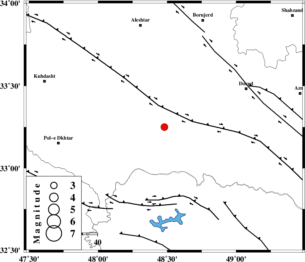
| Location | Lat:33.25 Lon: 48.48 |
| Region | Lorestan Province, 28 km South-East of Khorramabad |
Nearest Cities |
|
| 19 km South East of Daraei, Lorestan Province | |
| 20 km South West of Emanabad, Lorestan Province | |
| 23 km South of Kamalvand-e gholamali, Lorestan Province | |
| 25 km South East of Badrabad-e sofla, Lorestan Province | |
| 28 km South East of Khorramabad, Lorestan Province | |
| Depth | 18 km |
| Agency | |
Faults within 150 km: |
|
| HZF4 (Length: 492 km) , Distance to epicenter: 15 km | |
| BALARUD_F_Z2 (Length: 58 km) , Distance to epicenter: 47 km | |
| BALARUD_F_Z3 (Length: 53 km) , Distance to epicenter: 53 km | |
| Number of Phases | 4 |
| RMS | 0.1 |
| Number of Stations | 3 |
| Error in Latitude | >2.2 km |
| Error in Longitude | 4.7 km |
| Error in Depth | 5 km |
Download waveform in seisan format
to download seisan software Click here
to access information about IIEES stations Click here
Amplitude | ||||||||
| UID | Agency | Station | Component | Amplitude | Period | Arrival Time | Proccessing Time | Signal Clip |
| 87692 | IIEES | SNGE | E | 132.9 | 0.68 | 2013-01-24 03:10:32 | 2013-01-24 03:29:00 | n |
| 87693 | IIEES | SNGE | N | 220 | 0.52 | 2013-01-24 03:10:32 | 2013-01-24 03:29:00 | n |
Phase | ||||||||||||
| Agency | Station | Component | Phase Type | Phase Quality | First Motion | Observed Arrival Time | Time Residual | Loc. Flag | Input Weight | Distance | Azimuth | |
| IIEES | SHGR | Z | Pg | E | 2013-01-24 03:09:43 | 0.04 | y | 130 | 166 | |||
| IIEES | SNGE | Z | Pn | E | 2013-01-24 03:09:57 | -0.14 | y | 229 | 333 | |||
| IIEES | SNGE | E | Sg | E | 2013-01-24 03:10:27 | 0.09 | y | 229 | 333 | |||
| IIEES | GHVR | Z | Pn | E | 2013-01-24 03:10:05 | 0.01 | y | 290 | 61 | |||