
Magnitude |
3.2 |
| Date & Time (UTC) | 2013-01-25 02:37:43.0 |
| Date & Time (Local) | 1391/11/6 06:07:43.0 |
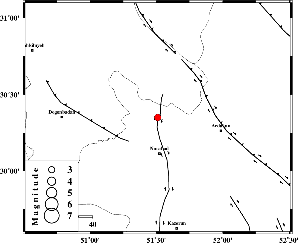
| Location | Lat:30.35 Lon: 51.51 |
| Region | Fars Province, 26 km North of Nurabad |
Nearest Cities |
|
| 12 km North of Masiri, Fars Province | |
| 13 km North East of Dehnumoqimi, Fars Province | |
| 14 km East of Chehar taq, Fars Province | |
| 19 km North of Fahlian-e olia, Fars Province | |
| 20 km North East of Kopon olia, Fars Province | |
| Depth | 46 km |
| Agency | |
Faults within 150 km: |
|
| KAZERUN_F (Length: 96 km) , Distance to epicenter: 3 km | |
| MISHAN_F (Length: 76 km) , Distance to epicenter: 27 km | |
| HZF3 (Length: 197 km) , Distance to epicenter: 38 km | |
| Number of Phases | 5 |
| RMS | 0.2 |
| Number of Stations | 3 |
| Error in Latitude | >7.3 km |
| Error in Longitude | 6.1 km |
| Error in Depth | 5.6 km |
Download waveform in seisan format
to download seisan software Click here
to access information about IIEES stations Click here
Amplitude | ||||||||
| UID | Agency | Station | Component | Amplitude | Period | Arrival Time | Proccessing Time | Signal Clip |
| 87706 | IIEES | AHRM | E | 258.2 | 0.44 | 2013-01-25 02:38:33 | 2013-01-25 03:21:00 | n |
| 87707 | IIEES | AHRM | N | 493.3 | 0.48 | 2013-01-25 02:38:34 | 2013-01-25 03:21:00 | n |
| 87708 | IIEES | GHIR | E | 103.8 | 0.4 | 2013-01-25 02:39:03 | 2013-01-25 03:21:00 | n |
| 87709 | IIEES | GHIR | N | 116.7 | 0.52 | 2013-01-25 02:39:03 | 2013-01-25 03:21:00 | n |
Phase | ||||||||||||
| Agency | Station | Component | Phase Type | Phase Quality | First Motion | Observed Arrival Time | Time Residual | Loc. Flag | Input Weight | Distance | Azimuth | |
| IIEES | AHRM | Z | Pg | E | 2013-01-25 02:38:10 | 0.06 | y | 166 | 187 | |||
| IIEES | AHRM | N | Sg | E | 2013-01-25 02:38:30 | 0.09 | y | 166 | 187 | |||
| IIEES | GHIR | Z | Pn | E | 2013-01-25 02:38:20 | -0.33 | y | 270 | 148 | |||
| IIEES | KRBR | Z | Pn | E | 2013-01-25 02:38:50 | 0.21 | y | 507 | 93 | |||
| IIEES | KRBR | N | Sg | E | 2013-01-25 02:40:01 | 0.05 | y | 507 | 93 | |||