
Magnitude |
2.9 |
| Date & Time (UTC) | 2013-01-29 16:49:15.0 |
| Date & Time (Local) | 1391/11/10 20:19:15.0 |
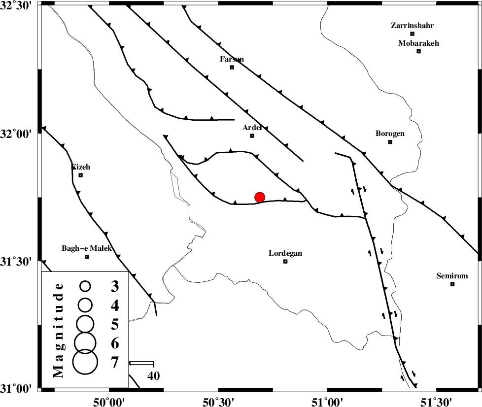
| Location | Lat:31.75 Lon: 50.69 |
| Region | Chaharmahal Bakhtiari Province, 27 km South of Ardel |
Nearest Cities |
|
| 13 km North East of Sarkhun, Chaharmahal Bakhtiari Province | |
| 16 km North West of Armand-e olia, Chaharmahal Bakhtiari Province | |
| 20 km South of Dupelan, Chaharmahal Bakhtiari Province | |
| 22 km South of Naghan, Chaharmahal Bakhtiari Province | |
| 27 km South of Ardel, Chaharmahal Bakhtiari Province | |
| Depth | 18 km |
| Agency | |
Faults within 150 km: |
|
| SABZKUH_F (Length: 67 km) , Distance to epicenter: 3 km | |
| DOPOLAN_F (Length: 107 km) , Distance to epicenter: 12 km | |
| ARDAL_F (Length: 170 km) , Distance to epicenter: 24 km | |
| Number of Phases | 4 |
| RMS | 0 |
| Number of Stations | 3 |
| Error in Latitude | >3.6 km |
| Error in Longitude | 10.3 km |
| Error in Depth | 10.5 km |
Download waveform in seisan format
to download seisan software Click here
to access information about IIEES stations Click here
Amplitude | ||||||||
| UID | Agency | Station | Component | Amplitude | Period | Arrival Time | Proccessing Time | Signal Clip |
| 87771 | IIEES | SHGR | N | 149.2 | 0.44 | 2013-01-29 16:50:24 | 2013-01-29 05:05:00 | n |
| 87772 | IIEES | SHGR | E | 127.5 | 0.52 | 2013-01-29 16:50:28 | 2013-01-29 05:05:00 | n |
| 87773 | IIEES | KHMZ | E | 65.1 | 0.56 | 2013-01-29 16:50:27 | 2013-01-29 05:05:00 | n |
Phase | ||||||||||||
| Agency | Station | Component | Phase Type | Phase Quality | First Motion | Observed Arrival Time | Time Residual | Loc. Flag | Input Weight | Distance | Azimuth | |
| IIEES | SHGR | Z | Pg | E | 2013-01-29 16:49:45 | 0 | y | 183 | 283 | |||
| IIEES | KHMZ | Z | Pn | E | 2013-01-29 16:49:51 | -0.02 | y | 231 | 343 | |||
| IIEES | KHMZ | N | Sg | E | 2013-01-29 16:50:20 | 0 | y | 231 | 343 | |||
| IIEES | GHVR | Z | Pn | E | 2013-01-29 16:50:00 | 0.02 | y | 307 | 10 | |||