
Magnitude |
2.9 |
| Date & Time (UTC) | 2013-02-13 14:50:56.5 |
| Date & Time (Local) | 1391/11/25 18:20:56.5 |
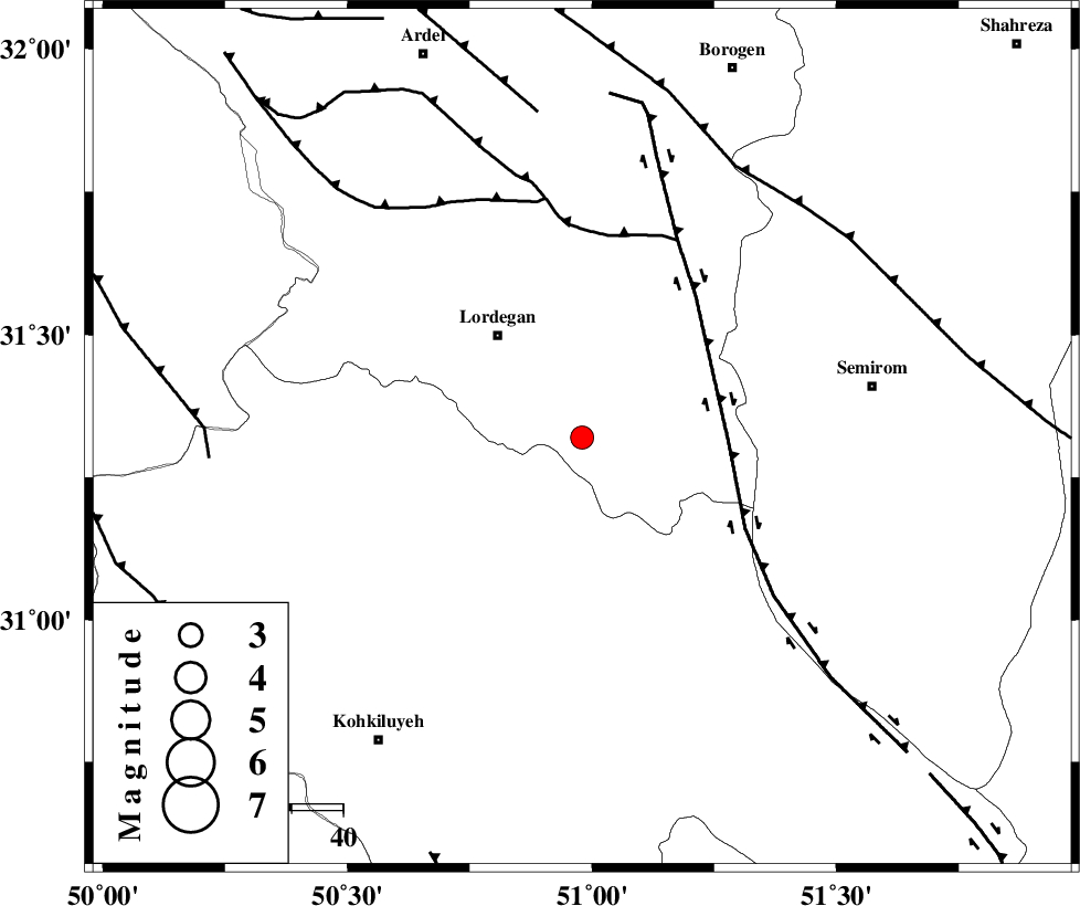
| Location | Lat:31.32 Lon: 50.98 |
| Region | Chaharmahal Bakhtiari Province, 26 km South-East of Lordegan |
Nearest Cities |
|
| 14 km East of Sardasht, Chaharmahal Bakhtiari Province | |
| 26 km South East of Lordegan, Chaharmahal Bakhtiari Province | |
| 27 km South of Aluni, Chaharmahal Bakhtiari Province | |
| 31 km North West of Malkhalifeh, Chaharmahal Bakhtiari Province | |
| 31 km North West of Dezhak, Kohkiluieh va boyerahmad Province | |
| Depth | 18 km |
| Agency | |
Faults within 150 km: |
|
| DENA_F (Length: 137 km) , Distance to epicenter: 29 km | |
| DOPOLAN_F (Length: 107 km) , Distance to epicenter: 40 km | |
| SABZKUH_F (Length: 67 km) , Distance to epicenter: 47 km | |
| Number of Phases | 5 |
| RMS | 0 |
| Number of Stations | 4 |
| Error in Latitude | >4.6 km |
| Error in Longitude | 2.4 km |
| Error in Depth | 8.7 km |
Download waveform in seisan format
to download seisan software Click here
to access information about IIEES stations Click here
Amplitude | ||||||||
| UID | Agency | Station | Component | Amplitude | Period | Arrival Time | Proccessing Time | Signal Clip |
| 87887 | IIEES | SHGR | N | 87 | 0.4 | 2013-02-13 14:52:06 | 2013-02-13 04:27:00 | n |
Phase | ||||||||||||
| Agency | Station | Component | Phase Type | Phase Quality | First Motion | Observed Arrival Time | Time Residual | Loc. Flag | Input Weight | Distance | Azimuth | |
| IIEES | SHGR | Z | P | E | 2013-02-13 14:51:31 | 0.02 | y | 224 | 294 | |||
| IIEES | KHMZ | Z | Pn | E | 2013-02-13 14:51:39 | -0.04 | y | 285 | 341 | |||
| IIEES | KHMZ | N | Sg | E | 2013-02-13 14:52:16 | 0.03 | y | 285 | 341 | |||
| IIEES | GHVR | Z | Pn | E | 2013-02-13 14:51:47 | -0.06 | y | 352 | 4 | |||
| IIEES | YZKH | Z | P | E | 2013-02-13 14:51:49 | 0.04 | y | 362 | 70 | |||