
Magnitude |
3.2 |
| Date & Time (UTC) | 2013-02-16 12:00:33.9 |
| Date & Time (Local) | 1391/11/28 15:30:33.9 |
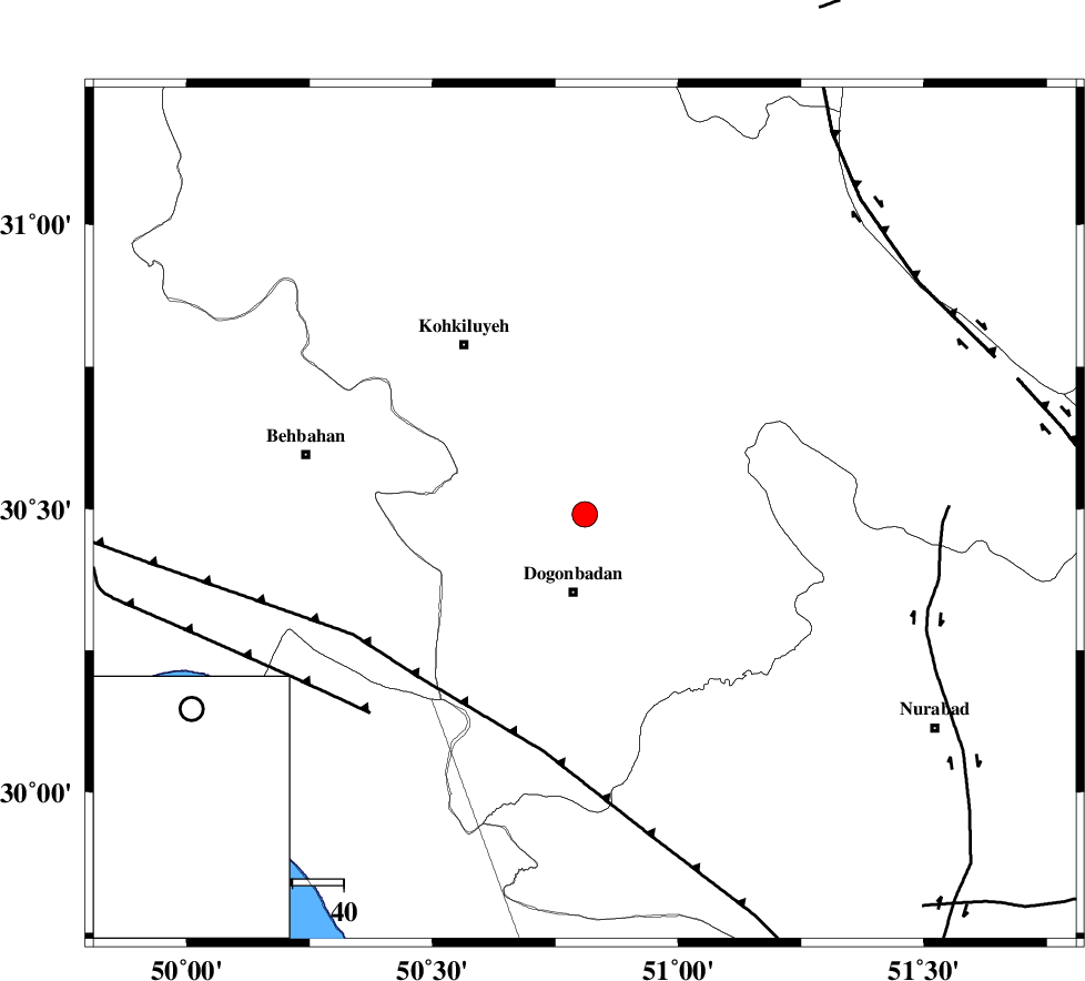
| Location | Lat:30.49 Lon: 50.81 |
| Region | Kohkiluieh va boyerahmad Province, 15 km North of Dogonbadan |
Nearest Cities |
|
| 15 km North of Dogonbadan, Kohkiluieh va boyerahmad Province | |
| 23 km North West of Abdehgah, Kohkiluieh va boyerahmad Province | |
| 37 km North West of Basht, Kohkiluieh va boyerahmad Province | |
| 41 km South East of Dehdasht, Kohkiluieh va boyerahmad Province | |
| 46 km South of Savari, Kohkiluieh va boyerahmad Province | |
| Depth | 18 km |
| Agency | |
Faults within 150 km: |
|
| MISHAN_F (Length: 76 km) , Distance to epicenter: 6 km | |
| ZFF3 (Length: 125 km) , Distance to epicenter: 57 km | |
| RAG_E_SEFID_F (Length: 84 km) , Distance to epicenter: 57 km | |
| Number of Phases | 4 |
| RMS | 0.1 |
| Number of Stations | 3 |
| Error in Latitude | >6.5 km |
| Error in Longitude | 4.3 km |
| Error in Depth | 17.8 km |
Download waveform in seisan format
to download seisan software Click here
to access information about IIEES stations Click here
Amplitude | ||||||||
| UID | Agency | Station | Component | Amplitude | Period | Arrival Time | Proccessing Time | Signal Clip |
| 87946 | IIEES | SHGR | E | 120.8 | 0.52 | 2013-02-16 12:01:48 | 2013-02-16 01:39:00 | n |
| 87947 | IIEES | SHGR | N | 109.4 | 0.48 | 2013-02-16 12:01:48 | 2013-02-16 01:39:00 | n |
Phase | ||||||||||||
| Agency | Station | Component | Phase Type | Phase Quality | First Motion | Observed Arrival Time | Time Residual | Loc. Flag | Input Weight | Distance | Azimuth | |
| IIEES | AHRM | Z | Pg | E | 2013-02-16 12:01:04 | 0.21 | y | 186 | 165 | |||
| IIEES | AHRM | N | Sg | E | 2013-02-16 12:01:26 | -0.14 | y | 186 | 165 | |||
| IIEES | SHGR | Z | Pn | E | 2013-02-16 12:01:13 | -0.05 | y | 262 | 314 | |||
| IIEES | YZKH | Z | Pn | E | 2013-02-16 12:01:33 | -0.03 | y | 417 | 59 | |||