
Magnitude |
3.1 |
| Date & Time (UTC) | 2013-03-02 21:06:28.0 |
| Date & Time (Local) | 1391/12/13 00:36:28.0 |
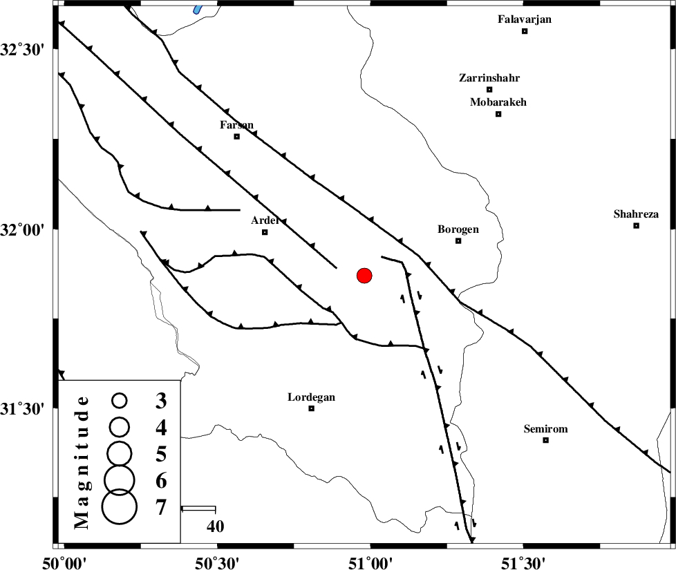
| Location | Lat:31.87 Lon: 50.98 |
| Region | Chaharmahal Bakhtiari Province, 31 km West of Borujen |
Nearest Cities |
|
| 9 km of Baladaji, Chaharmahal Bakhtiari Province | |
| 17 km North West of Gandoman, Chaharmahal Bakhtiari Province | |
| 24 km East of Naghan, Chaharmahal Bakhtiari Province | |
| 25 km South West of Faradonbeh, Chaharmahal Bakhtiari Province | |
| 25 km South East of Shalamzar, Chaharmahal Bakhtiari Province | |
| Depth | 46 km |
| Agency | |
Faults within 150 km: |
|
| DENA_F (Length: 137 km) , Distance to epicenter: 8 km | |
| ARDAL_F (Length: 170 km) , Distance to epicenter: 9 km | |
| DOPOLAN_F (Length: 107 km) , Distance to epicenter: 15 km | |
| Number of Phases | 7 |
| RMS | 0.2 |
| Number of Stations | 4 |
| Error in Latitude | >3.1 km |
| Error in Longitude | 1.8 km |
| Error in Depth | 3.7 km |
Download waveform in seisan format
to download seisan software Click here
to access information about IIEES stations Click here
Amplitude | ||||||||
| UID | Agency | Station | Component | Amplitude | Period | Arrival Time | Proccessing Time | Signal Clip |
| 88077 | IIEES | SHGR | N | 171.4 | 0.44 | 2013-03-02 21:07:33 | 2013-03-02 11:50:00 | n |
| 88078 | IIEES | SHGR | E | 145.5 | 0.52 | 2013-03-02 21:07:52 | 2013-03-02 11:50:00 | n |
| 88079 | IIEES | KHMZ | E | 115.2 | 0.56 | 2013-03-02 21:07:38 | 2013-03-02 11:50:00 | n |
Phase | ||||||||||||
| Agency | Station | Component | Phase Type | Phase Quality | First Motion | Observed Arrival Time | Time Residual | Loc. Flag | Input Weight | Distance | Azimuth | |
| IIEES | SHGR | Z | Pg | E | 2013-03-02 21:07:02 | 0.33 | y | 208 | 278 | |||
| IIEES | SHGR | N | Sg | E | 2013-03-02 21:07:26 | -0.25 | y | 208 | 278 | |||
| IIEES | KHMZ | Z | Pn | E | 2013-03-02 21:07:00 | -0.25 | y | 228 | 336 | |||
| IIEES | KHMZ | N | Sg | E | 2013-03-02 21:07:32 | 0.13 | y | 228 | 336 | |||
| IIEES | ASAO | Z | Pn | E | 2013-03-02 21:07:10 | 0.01 | y | 310 | 344 | |||
| IIEES | YZKH | Z | Pn | E | 2013-03-02 21:07:15 | 0.16 | y | 346 | 79 | |||
| IIEES | YZKH | N | Sg | E | 2013-03-02 21:08:03 | -0.13 | y | 346 | 79 | |||