
Magnitude |
3 |
| Date & Time (UTC) | 2013-03-03 06:18:55.7 |
| Date & Time (Local) | 1391/12/13 09:48:55.7 |
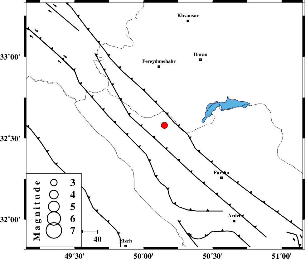
| Location | Lat:32.58 Lon: 50.15 |
| Region | Chaharmahal Bakhtiari Province, 13 km North of Chelgard |
Nearest Cities |
|
| 13 km North West of Kukanak, Esfahan Province | |
| 13 km North of Chelgard, Chaharmahal Bakhtiari Province | |
| 18 km South of Ghale? sorkh, Esfahan Province | |
| 26 km West of Organ, Esfahan Province | |
| 26 km West of Faramushjan, Esfahan Province | |
| Depth | 15 km |
| Agency | |
Faults within 150 km: |
|
| MAIN_ZAGROS_R_F (Length: 1106 km) , Distance to epicenter: 7 km | |
| ARDAL_F (Length: 170 km) , Distance to epicenter: 11 km | |
| ZARDKUH_F (Length: 139 km) , Distance to epicenter: 23 km | |
| Number of Phases | 6 |
| RMS | 0.3 |
| Number of Stations | 7 |
| Error in Latitude | >4.5 km |
| Error in Longitude | 6.4 km |
| Error in Depth | 7 km |
Download waveform in seisan format
to download seisan software Click here
to access information about IIEES stations Click here
Amplitude | ||||||||
| UID | Agency | Station | Component | Amplitude | Period | Arrival Time | Proccessing Time | Signal Clip |
| 88080 | IIEES | SHGR | E | 302.6 | 0.43 | 2013-03-03 06:19:42 | 2013-03-03 06:40:00 | n |
| 88081 | IIEES | GHVR | N | 94.4 | 0.7 | 2013-03-03 06:20:11 | 2013-03-03 06:40:00 | n |
Phase | ||||||||||||
| Agency | Station | Component | Phase Type | Phase Quality | First Motion | Observed Arrival Time | Time Residual | Loc. Flag | Input Weight | Distance | Azimuth | |
| IIEES | KHMZ | Z | Pg | E | 2013-03-03 06:19:16 | -0.5 | y | 130 | 352 | |||
| IIEES | SHGR | Z | Pg | E | 2013-03-03 06:19:18 | -0.18 | y | 137 | 248 | |||
| IIEES | ASAO | Z | Pn | E | 2013-03-03 06:19:30 | 0.35 | y | 218 | 357 | |||
| IIEES | CHTH | Z | Pn | E | 2013-03-03 06:19:50 | -0.15 | y | 380 | 13 | |||
| IIEES | SNGE | Z | Pn | E | 2013-03-03 06:19:51 | 0.52 | y | 381 | 318 | |||
| IIEES | YZKH | Z | Pn | E | 2013-03-03 06:19:55 | 0.04 | y | 418 | 92 | |||