
Magnitude |
2 |
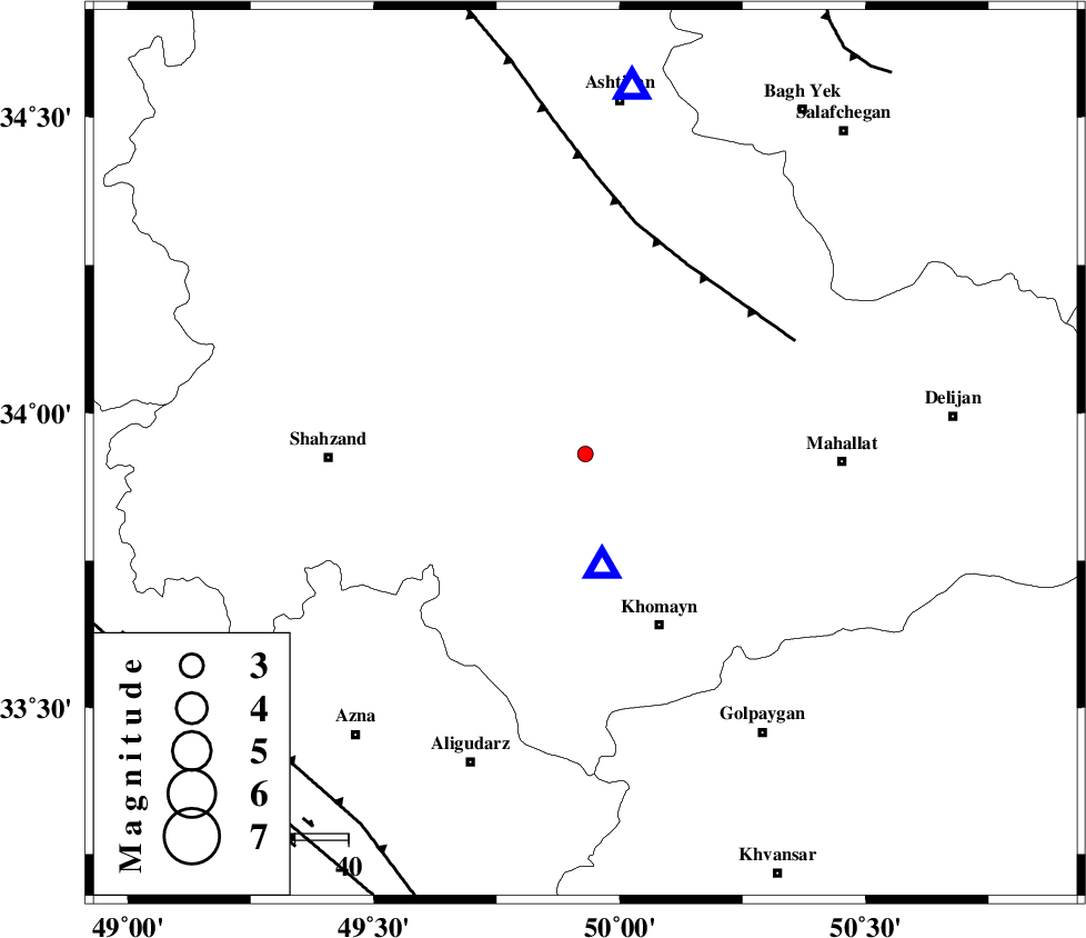
| Date & Time (UTC) | 2013-03-06 10:30:23.3 |
| Date & Time (Local) | 1391/12/16 14:00:23.3 |
| Location | Lat:33.93 Lon: 49.93 |
| Region | Markazi Province, 29 km South-East of Arak |
Nearest Cities |
|
| 5 km of Amanabad, Markazi Province | |
| 19 km North East of Qasemabad, Markazi Province | |
| 21 km North West of Sarkuye, Markazi Province | |
| 29 km South East of Arak, Markazi Province | |
| 30 km North of Qorchibashi, Markazi Province | |
| Depth | 18 km |
| Agency | |
Faults within 150 km: |
|
| TAFRESH_F (Length: 117 km) , Distance to epicenter: 40 km | |
| MAIN_ZAGROS_R_F (Length: 1106 km) , Distance to epicenter: 81 km | |
| DORUD (Length: 100 km) , Distance to epicenter: 90 km | |
| Number of Phases | 6 |
| RMS | 0.2 |
| Number of Stations | 4 |
| Error in Latitude | >3.5 km |
| Error in Longitude | 2.3 km |
| Error in Depth | 5.9 km |
Download waveform in seisan format
to download seisan software Click here
to access information about IIEES stations Click here
Amplitude | ||||||||
| UID | Agency | Station | Component | Amplitude | Period | Arrival Time | Proccessing Time | Signal Clip |
| 88111 | IIEES | KHMZ | N | 256.4 | 0.51 | 2013-03-06 10:30:36 | 2013-03-06 11:07:00 | n |
| 88112 | IIEES | GHVR | E | 37.8 | 0.35 | 2013-03-06 10:31:04 | 2013-03-06 11:07:00 | n |
| 88113 | IIEES | SNGE | N | 7.4 | 0.48 | 2013-03-06 10:31:44 | 2013-03-06 11:07:00 | n |
Phase | ||||||||||||
| Agency | Station | Component | Phase Type | Phase Quality | First Motion | Observed Arrival Time | Time Residual | Loc. Flag | Input Weight | Distance | Azimuth | |
| IIEES | KHMZ | Z | Pg | E | 2013-03-06 10:30:28 | 0 | y | 20.8 | 170 | |||
| IIEES | ASAO | Z | Pg | E | 2013-03-06 10:30:35 | -0.41 | y | 69.7 | 7 | |||
| IIEES | GHVR | Z | Pg | E | 2013-03-06 10:30:45 | -0.07 | y | 136 | 63 | |||
| IIEES | GHVR | E | Sg | E | 2013-03-06 10:31:02 | 0.31 | y | 136 | 63 | |||
| IIEES | SNGE | Z | Pn | E | 2013-03-06 10:31:04 | -0.11 | y | 270 | 299 | |||
| IIEES | SNGE | N | Sg | E | 2013-03-06 10:31:39 | 0.29 | y | 270 | 299 | |||