
Magnitude |
3.2 |
| Date & Time (UTC) | 2013-03-11 22:57:19.3 |
| Date & Time (Local) | 1391/12/22 02:27:19.3 |
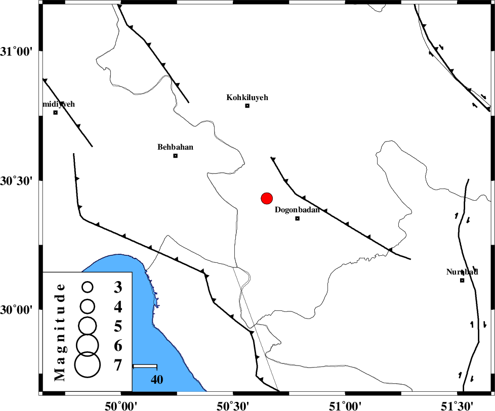
| Location | Lat:30.43 Lon: 50.65 |
| Region | Kohkiluieh va boyerahmad Province, 16 km West of Dogonbadan |
Nearest Cities |
|
| 16 km North West of Dogonbadan, Kohkiluieh va boyerahmad Province | |
| 38 km West of Abdehgah, Kohkiluieh va boyerahmad Province | |
| 40 km South East of Mansuriyeh, Khoozestan Province | |
| 41 km South of Dehdasht, Kohkiluieh va boyerahmad Province | |
| 43 km North East of Sardasht, Khoozestan Province | |
| Depth | 42 km |
| Agency | |
Faults within 150 km: |
|
| MISHAN_F (Length: 76 km) , Distance to epicenter: 11 km | |
| ZFF3 (Length: 125 km) , Distance to epicenter: 42 km | |
| RAG_E_SEFID_F (Length: 84 km) , Distance to epicenter: 42 km | |
| Number of Phases | 8 |
| RMS | 0.1 |
| Number of Stations | 6 |
| Error in Latitude | >2 km |
| Error in Longitude | 3.3 km |
| Error in Depth | 3.4 km |
Download waveform in seisan format
to download seisan software Click here
to access information about IIEES stations Click here
Amplitude | ||||||||
| UID | Agency | Station | Component | Amplitude | Period | Arrival Time | Proccessing Time | Signal Clip |
| 88185 | IIEES | SHGR | N | 135.7 | 0.44 | 2013-03-11 22:58:35 | 2013-03-11 11:30:00 | n |
| 88186 | IIEES | SHGR | E | 136.3 | 0.32 | 2013-03-11 22:58:38 | 2013-03-11 11:30:00 | n |
Phase | ||||||||||||
| Agency | Station | Component | Phase Type | Phase Quality | First Motion | Observed Arrival Time | Time Residual | Loc. Flag | Input Weight | Distance | Azimuth | |
| IIEES | AHRM | Z | Pg | E | 2013-03-11 22:57:49 | -0.03 | y | 185 | 160 | |||
| IIEES | AHRM | N | Sg | E | 2013-03-11 22:58:11 | 0.1 | y | 185 | 160 | |||
| IIEES | SHGR | Z | Pn | E | 2013-03-11 22:57:56 | 0.06 | y | 256 | 317 | |||
| IIEES | SHGR | N | Sg | E | 2013-03-11 22:58:30 | -0.08 | y | 256 | 317 | |||
| IIEES | GHIR | Z | Pn | E | 2013-03-11 22:58:05 | -0.19 | y | 329 | 136 | |||
| IIEES | KHMZ | Z | Pn | E | 2013-03-11 22:58:11 | 0.11 | y | 372 | 350 | |||
| IIEES | YZKH | Z | Pn | E | 2013-03-11 22:58:18 | -0.01 | y | 433 | 59 | |||
| IIEES | GHVR | Z | Pn | E | 2013-03-11 22:58:20 | 0.05 | y | 452 | 7 | |||