
Magnitude |
2.1 |
| Date & Time (UTC) | 2013-03-20 16:53:19.9 |
| Date & Time (Local) | 1391/12/30 20:23:19.9 |
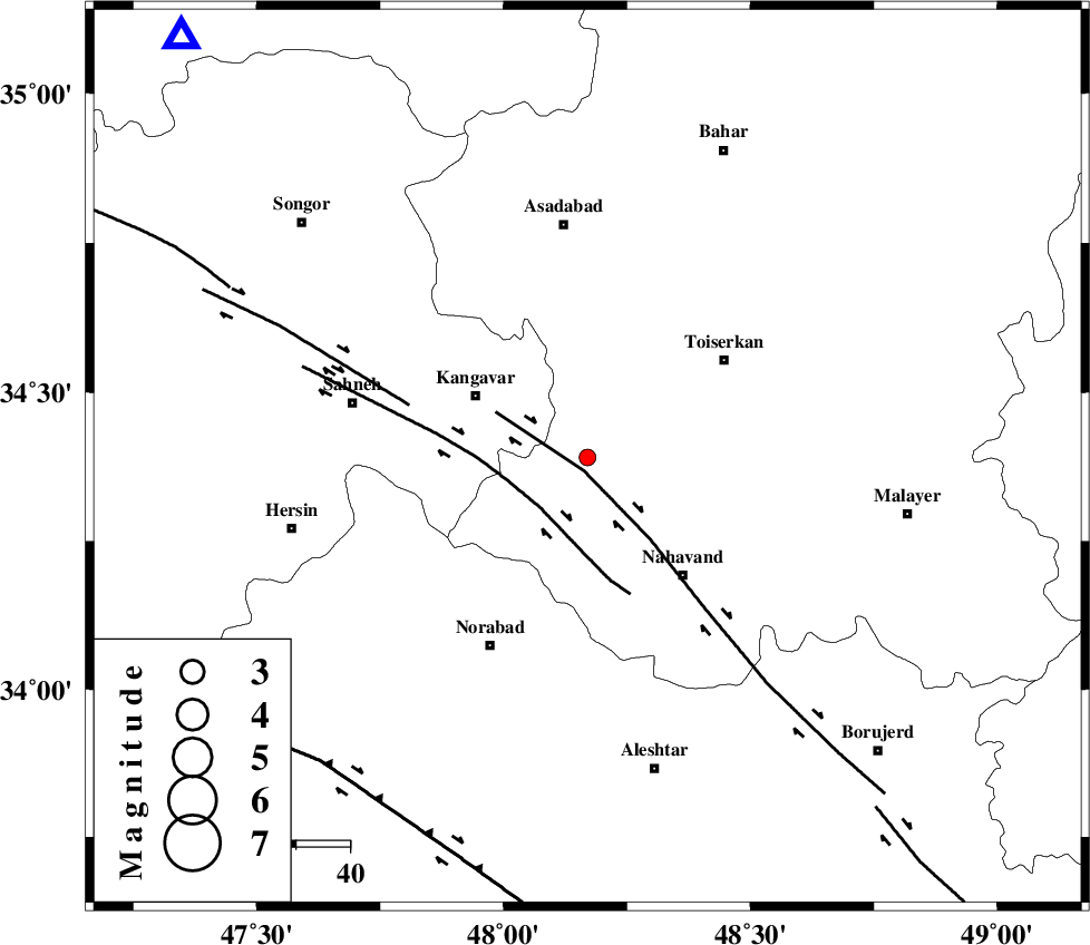
| Location | Lat:34.39 Lon: 48.17 |
| Region | Hamedan Province, 24 km South-East of Kangavar |
Nearest Cities |
|
| 3 km North of Firuzan, Hamedan Province | |
| 13 km North of Shahrak, Hamedan Province | |
| 15 km West of Farsang, Hamedan Province | |
| 17 km South of Gudin, Kermanshah Province | |
| 21 km North of Barzul, Hamedan Province | |
| Depth | 14 km |
| Agency | |
Faults within 150 km: |
|
| NAHAVAND_F (Length: 102 km) , Distance to epicenter: 3 km | |
| SAHANEH_F (Length: 77 km) , Distance to epicenter: 13 km | |
| DINEHVAR_F (Length: 46 km) , Distance to epicenter: 35 km | |
| Number of Phases | 6 |
| RMS | 0.1 |
| Number of Stations | 4 |
| Error in Latitude | >3 km |
| Error in Longitude | 1.8 km |
| Error in Depth | 3.9 km |
Download waveform in seisan format
to download seisan software Click here
to access information about IIEES stations Click here
Amplitude | ||||||||
| UID | Agency | Station | Component | Amplitude | Period | Arrival Time | Proccessing Time | Signal Clip |
| 88264 | IIEES | GHVR | E | 8.2 | 0.4 | 2013-03-20 16:54:48 | 2013-03-20 05:33:00 | n |
Phase | ||||||||||||
| Agency | Station | Component | Phase Type | Phase Quality | First Motion | Observed Arrival Time | Time Residual | Loc. Flag | Input Weight | Distance | Azimuth | |
| IIEES | SNGE | Z | Pg | E | 2013-03-20 16:53:38 | -0.01 | y | 109 | 316 | |||
| IIEES | SNGE | E | Sg | E | 2013-03-20 16:53:51 | 0.02 | y | 109 | 316 | |||
| IIEES | ASAO | Z | Pg | E | 2013-03-20 16:53:48 | -0.11 | y | 171 | 84 | |||
| IIEES | ASAO | E | Sg | E | 2013-03-20 16:54:09 | 0.02 | y | 171 | 84 | |||
| IIEES | KHMZ | Z | Pg | E | 2013-03-20 16:53:49 | -0.03 | y | 180 | 113 | |||
| IIEES | GHVR | Z | Pn | E | 2013-03-20 16:54:02 | 0.12 | y | 283 | 87 | |||