
Magnitude |
3.1 |
| Date & Time (UTC) | 2013-03-23 11:02:39.8 |
| Date & Time (Local) | 1392/1/3 15:32:39.8 |
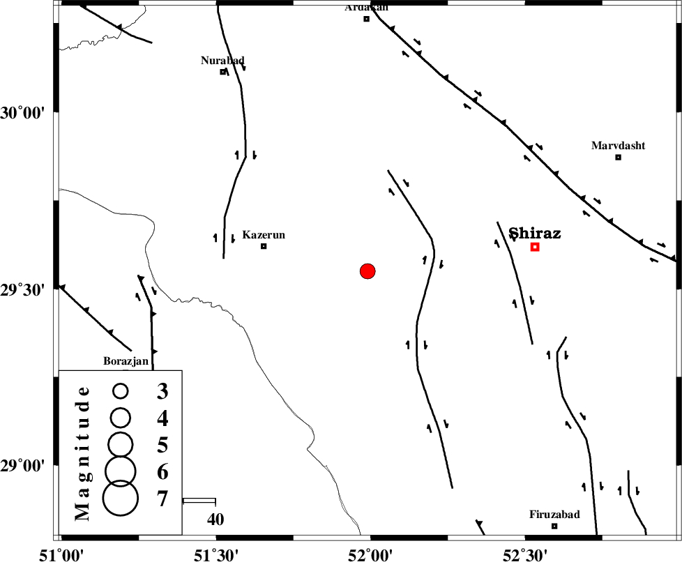
| Location | Lat:29.55 Lon: 51.99 |
| Region | Fars Province, 33 km East of Kazerun |
Nearest Cities |
|
| 12 km East of Kalani, Fars Province | |
| 18 km North West of Richi, Fars Province | |
| 26 km South West of Khanehzanian, Fars Province | |
| 28 km North East of Dadin-e olia, Fars Province | |
| 30 km North of Baladeh, Fars Province | |
| Depth | 17 km |
| Agency | |
Faults within 150 km: |
|
| KAREBASS_F (Length: 98 km) , Distance to epicenter: 20 km | |
| SABZ_PUSHAN_F_Z3 (Length: 37 km) , Distance to epicenter: 43 km | |
| KAZERUN_F (Length: 96 km) , Distance to epicenter: 45 km | |
| Number of Phases | 6 |
| RMS | 0 |
| Number of Stations | 4 |
| Error in Latitude | >3.5 km |
| Error in Longitude | 1.6 km |
| Error in Depth | 9.5 km |
Download waveform in seisan format
to download seisan software Click here
to access information about IIEES stations Click here
Amplitude | ||||||||
| UID | Agency | Station | Component | Amplitude | Period | Arrival Time | Proccessing Time | Signal Clip |
| 88297 | IIEES | AHRM | E | 664.2 | 0.48 | 2013-03-23 11:03:15 | 2013-03-23 12:07:00 | n |
| 88298 | IIEES | AHRM | N | 578 | 0.32 | 2013-03-23 11:03:16 | 2013-03-23 12:07:00 | n |
| 88299 | IIEES | GHIR | N | 274.3 | 0.52 | 2013-03-23 11:03:38 | 2013-03-23 12:07:00 | n |
| 88300 | IIEES | GHIR | E | 234.6 | 0.44 | 2013-03-23 11:03:39 | 2013-03-23 12:07:00 | n |
Phase | ||||||||||||
| Agency | Station | Component | Phase Type | Phase Quality | First Motion | Observed Arrival Time | Time Residual | Loc. Flag | Input Weight | Distance | Azimuth | |
| IIEES | AHRM | Z | Pg | E | 2013-03-23 11:02:56 | 0.02 | y | 101 | 222 | |||
| IIEES | AHRM | N | Sg | E | 2013-03-23 11:03:09 | -0.02 | y | 101 | 222 | |||
| IIEES | GHIR | Z | P | E | 2013-03-23 11:03:07 | 0.01 | y | 170 | 145 | |||
| IIEES | GHIR | N | Sg | E | 2013-03-23 11:03:28 | -0.01 | y | 170 | 145 | |||
| IIEES | YZKH | Z | Pn | E | 2013-03-23 11:03:37 | -0.03 | y | 402 | 38 | |||
| IIEES | KRBR | Z | Pn | E | 2013-03-23 11:03:45 | 0.03 | y | 464 | 83 | |||