
Magnitude |
2.1 |
| Date & Time (UTC) | 2013-04-03 22:31:42.9 |
| Date & Time (Local) | 1392/1/15 03:01:42.9 |
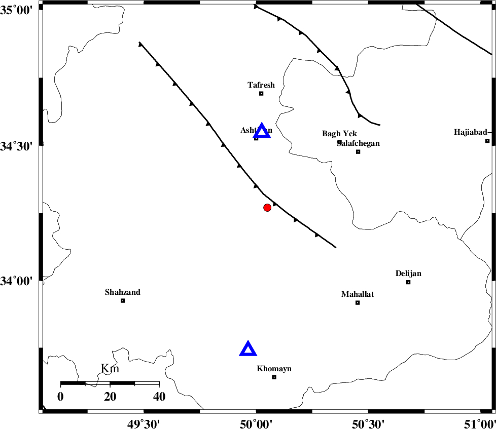
| Location | Lat:34.27 Lon: 50.05 |
| Region | Markazi Province, 29 km South of Ashtiyan |
Nearest Cities |
|
| 8 km North of Ebrahimabad, Markazi Province | |
| 17 km East of Davoodabad, Markazi Province | |
| 18 km South West of Salehabad, Markazi Province | |
| 29 km South of Ashtiyan, Markazi Province | |
| 32 km North East of Ebakabad, Markazi Province | |
| Depth | 10 km |
| Agency | |
Faults within 150 km: |
|
| TAFRESH_F (Length: 117 km) , Distance to epicenter: 6 km | |
| INDES_F (Length: 98 km) , Distance to epicenter: 54 km | |
| KUSHK_E_NOSRAT_F (Length: 230 km) , Distance to epicenter: 103 km | |
| Number of Phases | 6 |
| RMS | 0 |
| Number of Stations | 4 |
| Error in Latitude | >0.7 km |
| Error in Longitude | 2.4 km |
| Error in Depth | 2.2 km |
Download waveform in seisan format
to download seisan software Click here
to access information about IIEES stations Click here
Amplitude | ||||||||
| UID | Agency | Station | Component | Amplitude | Period | Arrival Time | Proccessing Time | Signal Clip |
| 88394 | IIEES | GHVR | E | 42.8 | 0.44 | 2013-04-03 22:32:18 | 2013-04-04 04:01:00 | n |
| 88395 | IIEES | GHVR | N | 46.4 | 0.44 | 2013-04-03 22:32:18 | 2013-04-04 04:01:00 | n |
Phase | ||||||||||||
| Agency | Station | Component | Phase Type | Phase Quality | First Motion | Observed Arrival Time | Time Residual | Loc. Flag | Input Weight | Distance | Azimuth | |
| IIEES | ASAO | Z | Pg | E | 2013-04-03 22:31:48 | -0.06 | y | 31.3 | 356 | |||
| IIEES | ASAO | E | Sg | E | 2013-04-03 22:31:53 | 0.04 | y | 31.3 | 356 | |||
| IIEES | KHMZ | Z | Pg | E | 2013-04-03 22:31:53 | 0.03 | y | 58.9 | 187 | |||
| IIEES | KHMZ | E | Sg | E | 2013-04-03 22:32:01 | -0.01 | y | 58.9 | 187 | |||
| IIEES | GHVR | Z | Pg | E | 2013-04-03 22:32:02 | 0 | y | 113 | 78 | |||
| IIEES | CHTH | Z | Pn | E | 2013-04-03 22:32:16 | 0 | y | 207 | 28 | |||