
Magnitude |
3.4 |
| Date & Time (UTC) | 2013-04-04 15:55:13.2 |
| Date & Time (Local) | 1392/1/15 20:25:13.2 |
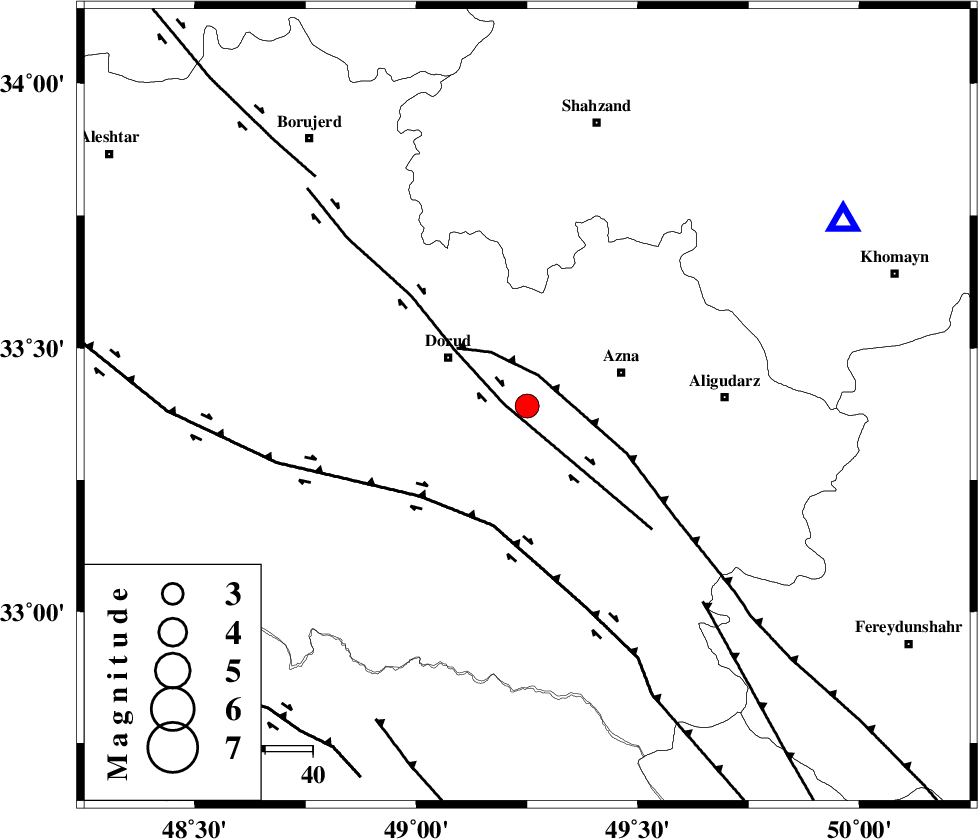
| Location | Lat:33.39 Lon: 49.25 |
| Region | Lorestan Province, 20 km East of Dorud |
Nearest Cities |
|
| 9 km of Darband, Lorestan Province | |
| 10 km of Heshmatabad, Lorestan Province | |
| 19 km East of Dorud, Lorestan Province | |
| 21 km South East of Zhan, Lorestan Province | |
| 21 km West of Azna, Lorestan Province | |
| Depth | 14 km |
| Agency | |
Faults within 150 km: |
|
| DORUD (Length: 100 km) , Distance to epicenter: 5 km | |
| MAIN_ZAGROS_R_F (Length: 1106 km) , Distance to epicenter: 7 km | |
| HZF4 (Length: 492 km) , Distance to epicenter: 26 km | |
| Number of Phases | 5 |
| RMS | 0.1 |
| Number of Stations | 4 |
| Error in Latitude | >3.7 km |
| Error in Longitude | 4.6 km |
| Error in Depth | 6.3 km |
Download waveform in seisan format
to download seisan software Click here
to access information about IIEES stations Click here
Amplitude | ||||||||
| UID | Agency | Station | Component | Amplitude | Period | Arrival Time | Proccessing Time | Signal Clip |
| 88396 | IIEES | SHGR | E | 594.9 | 0.52 | 2013-04-04 15:56:04 | 2013-04-04 05:18:00 | n |
| 88397 | IIEES | SHGR | N | 755.1 | 0.44 | 2013-04-04 15:56:05 | 2013-04-04 05:18:00 | n |
| 88398 | IIEES | GHVR | E | 302.5 | 0.56 | 2013-04-04 15:56:25 | 2013-04-04 05:18:00 | n |
| 88399 | IIEES | GHVR | N | 304.6 | 0.56 | 2013-04-04 15:56:26 | 2013-04-04 05:18:00 | n |
Phase | ||||||||||||
| Agency | Station | Component | Phase Type | Phase Quality | First Motion | Observed Arrival Time | Time Residual | Loc. Flag | Input Weight | Distance | Azimuth | |
| IIEES | SHGR | Z | Pg | E | 2013-04-04 15:55:37 | -0.05 | y | 148 | 197 | |||
| IIEES | GHVR | Z | Pn | E | 2013-04-04 15:55:48 | 0.15 | y | 220 | 56 | |||
| IIEES | GHVR | N | Sg | E | 2013-04-04 15:56:15 | -0.12 | y | 220 | 56 | |||
| IIEES | CHTH | Z | Pn | E | 2013-04-04 15:56:02 | 0.15 | y | 328 | 31 | |||
| IIEES | ZNJK | Z | Pn | E | 2013-04-04 15:56:06 | -0.13 | y | 368 | 352 | |||