
Magnitude |
2.6 |
| Date & Time (UTC) | 2013-04-06 20:15:48.9 |
| Date & Time (Local) | 1392/1/18 00:45:48.9 |
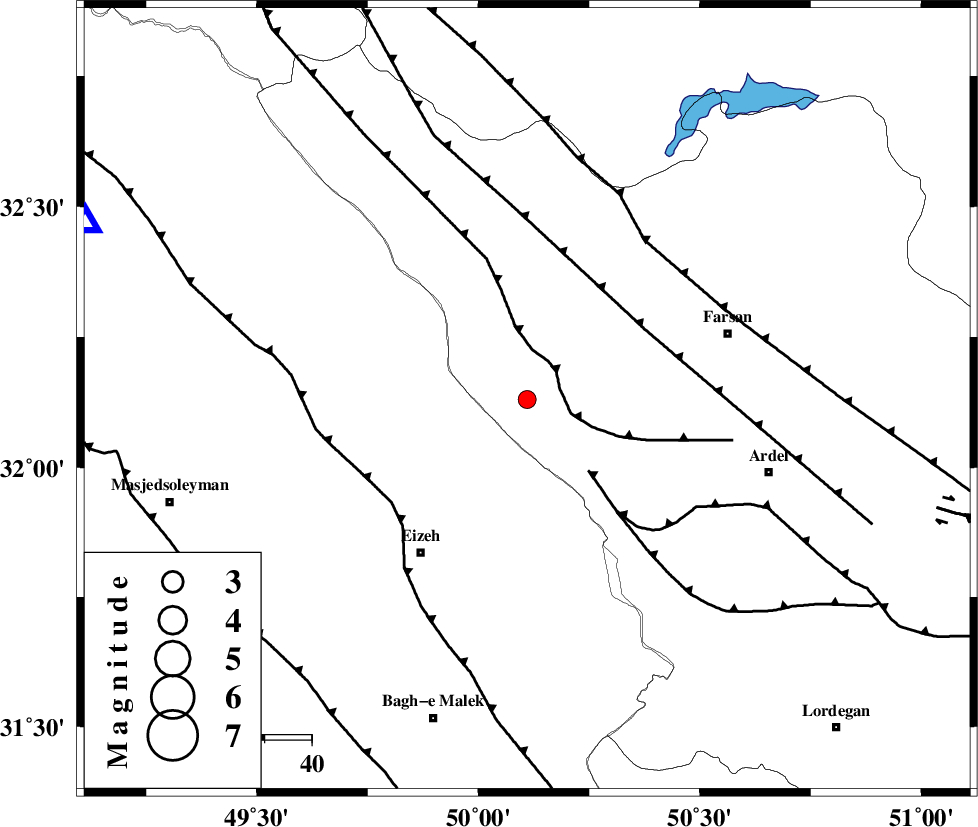
| Location | Lat:32.13 Lon: 50.11 |
| Region | Chaharmahal Bakhtiari Province, 38 km South of Chelgard |
Nearest Cities |
|
| 31 km North East of Torshak, Khoozestan Province | |
| 37 km South of Chelgard, Chaharmahal Bakhtiari Province | |
| 40 km North East of Izeh, Khoozestan Province | |
| 41 km North East of Rasvand, Khoozestan Province | |
| 41 km North West of Rostamabad, Chaharmahal Bakhtiari Province | |
| Depth | 17 km |
| Agency | |
Faults within 150 km: |
|
| ZARDKUH_F (Length: 139 km) , Distance to epicenter: 7 km | |
| DOPOLAN_F (Length: 107 km) , Distance to epicenter: 20 km | |
| ARDAL_F (Length: 170 km) , Distance to epicenter: 29 km | |
| Number of Phases | 4 |
| RMS | 0 |
| Number of Stations | 4 |
| Error in Latitude | >8.1 km |
| Error in Longitude | 9.9 km |
| Error in Depth | 6.6 km |
Download waveform in seisan format
to download seisan software Click here
to access information about IIEES stations Click here
Amplitude | ||||||||
| UID | Agency | Station | Component | Amplitude | Period | Arrival Time | Proccessing Time | Signal Clip |
| 88412 | IIEES | SHGR | N | 130.7 | 0.32 | 2013-04-06 20:16:32 | 2013-04-06 10:48:00 | n |
| 88413 | IIEES | SHGR | E | 128.4 | 0.56 | 2013-04-06 20:16:43 | 2013-04-06 10:48:00 | n |
Phase | ||||||||||||
| Agency | Station | Component | Phase Type | Phase Quality | First Motion | Observed Arrival Time | Time Residual | Loc. Flag | Input Weight | Distance | Azimuth | |
| IIEES | SHGR | Z | Pg | E | 2013-04-06 20:16:09 | 0 | y | 123 | 269 | |||
| IIEES | KHMZ | Z | Pg | E | 2013-04-06 20:16:18 | 0 | y | 180 | 356 | |||
| IIEES | ASAO | Z | Pn | E | 2013-04-06 20:16:29 | -0.01 | y | 269 | 358 | |||
| IIEES | GHVR | Z | Pn | E | 2013-04-06 20:16:31 | 0.01 | y | 282 | 22 | |||