
Magnitude |
1.9 |
| Date & Time (UTC) | 2013-04-06 20:07:58.1 |
| Date & Time (Local) | 1392/1/18 00:37:58.1 |
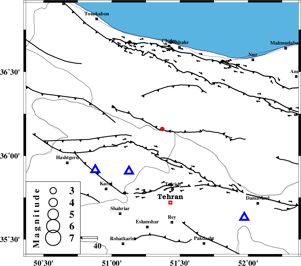
| Location | Lat:36.16 Lon: 51.37 |
| Region | Mazandaran Province, 41 km North of Tajrish |
Nearest Cities |
|
| 7 km of Pol-e zanguleh, Mazandaran Province | |
| 9 km North of Nesa, Tehran Province | |
| 19 km West of Void, Mazandaran Province | |
| 20 km North of Asara, Tehran Province | |
| 25 km North West of Meygon, Tehran Province | |
| Depth | 18 km |
| Agency | |
Faults within 150 km: |
|
| KANDOVAN_F (Length: 90 km) , Distance to epicenter: 3 km | |
| MOSHA_F (Length: 234 km) , Distance to epicenter: 15 km | |
| TALEGHAN_F (Length: 71 km) , Distance to epicenter: 17 km | |
| Number of Phases | 4 |
| RMS | 0 |
| Number of Stations | 3 |
| Error in Latitude | >6.2 km |
| Error in Longitude | 4.8 km |
| Error in Depth | 3.6 km |
Download waveform in seisan format
to download seisan software Click here
to access information about IIEES stations Click here
Amplitude | ||||||||
| UID | Agency | Station | Component | Amplitude | Period | Arrival Time | Proccessing Time | Signal Clip |
| 88414 | IIEES | GHVR | E | 12.6 | 0.24 | 2013-04-06 20:08:52 | 2013-04-07 03:26:00 | n |
| 88415 | IIEES | GHVR | N | 17.4 | 0.44 | 2013-04-06 20:08:52 | 2013-04-07 03:26:00 | n |
| 88416 | IIEES | ASAO | E | 6.4 | 0.4 | 2013-04-06 20:09:01 | 2013-04-07 03:26:00 | n |
Phase | ||||||||||||
| Agency | Station | Component | Phase Type | Phase Quality | First Motion | Observed Arrival Time | Time Residual | Loc. Flag | Input Weight | Distance | Azimuth | |
| IIEES | CHTH | Z | Pg | E | 2013-04-06 20:08:05 | 0 | y | 35.3 | 218 | |||
| IIEES | CHTH | E | Sg | E | 2013-04-06 20:08:10 | 0 | y | 35.3 | 218 | |||
| IIEES | GHVR | Z | Pg | E | 2013-04-06 20:08:28 | 0 | y | 187 | 183 | |||
| IIEES | ASAO | Z | Pn | E | 2013-04-06 20:08:32 | 0 | y | 216 | 215 | |||