
Magnitude |
3.5 |
| Date & Time (UTC) | 2013-04-07 23:06:11.4 |
| Date & Time (Local) | 1392/1/19 03:36:11.4 |
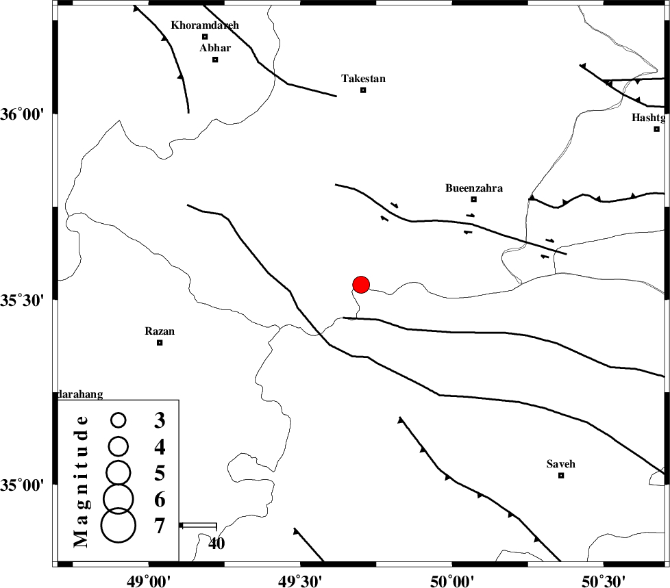
| Location | Lat:35.54 Lon: 49.7 |
| Region | Ghazvin Province, 58 km South of Takestan |
Nearest Cities |
|
| 19 km North West of Duzaj, Markazi Province | |
| 23 km East of Kolanjin, Ghazvin Province | |
| 27 km South of Danesfahan, Ghazvin Province | |
| 33 km North West of Razegian, Markazi Province | |
| 33 km South West of Sagezabad, Ghazvin Province | |
| Depth | 15 km |
| Agency | |
Faults within 150 km: |
|
| S_PARANDAK_F (Length: 116 km) , Distance to epicenter: 11 km | |
| KUSHK_E_NOSRAT_F (Length: 230 km) , Distance to epicenter: 19 km | |
| IPAK_F (Length: 80 km) , Distance to epicenter: 23 km | |
| Number of Phases | 7 |
| RMS | 0 |
| Number of Stations | 5 |
| Error in Latitude | >0.7 km |
| Error in Longitude | 1.1 km |
| Error in Depth | 3.2 km |
Download waveform in seisan format
to download seisan software Click here
to access information about IIEES stations Click here
Amplitude | ||||||||
| UID | Agency | Station | Component | Amplitude | Period | Arrival Time | Proccessing Time | Signal Clip |
| 88430 | IIEES | GHVR | E | 524.1 | 0.56 | 2013-04-07 23:07:12 | 2013-04-08 12:29:00 | n |
| 88431 | IIEES | GHVR | N | 518 | 0.36 | 2013-04-07 23:07:12 | 2013-04-08 12:29:00 | n |
Phase | ||||||||||||
| Agency | Station | Component | Phase Type | Phase Quality | First Motion | Observed Arrival Time | Time Residual | Loc. Flag | Input Weight | Distance | Azimuth | |
| IIEES | ASAO | Z | Pg | E | 2013-04-07 23:06:30 | 0.06 | y | 114 | 165 | |||
| IIEES | ASAO | E | Sg | E | 2013-04-07 23:06:44 | -0.04 | y | 114 | 165 | |||
| IIEES | CHTH | Z | Pg | E | 2013-04-07 23:06:34 | -0.01 | y | 135 | 72 | |||
| IIEES | CHTH | E | Sg | E | 2013-04-07 23:06:50 | 0.01 | y | 135 | 72 | |||
| IIEES | ZNJK | Z | Pg | E | 2013-04-07 23:06:37 | -0.02 | y | 155 | 324 | |||
| IIEES | ZNJK | E | Sg | E | 2013-04-07 23:06:56 | 0.01 | y | 155 | 324 | |||
| IIEES | KHMZ | Z | Pn | E | 2013-04-07 23:06:44 | 0 | y | 201 | 173 | |||