
Magnitude |
2.1 |
| Date & Time (UTC) | 2013-04-13 10:01:23.3 |
| Date & Time (Local) | 1392/1/24 14:31:23.3 |
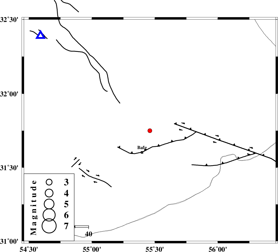
| Location | Lat:31.75 Lon: 55.46 |
| Region | Yazd Province, 17 km North of Bafq |
Nearest Cities |
|
| 14 km North of Mobarake, Yazd Province | |
| 17 km North of Bafq, Yazd Province | |
| 31 km North West of Kushk, Yazd Province | |
| 55 km South West of Behabad, Yazd Province | |
| 58 km North West of Basab, Yazd Province | |
| Depth | 14 km |
| Agency | |
Faults within 150 km: |
|
| POSHT_E_BADAM_F (Length: 128 km) , Distance to epicenter: 23 km | |
| DARIVAN_F (Length: 131 km) , Distance to epicenter: 40 km | |
| ANAR_F (Length: 91 km) , Distance to epicenter: 42 km | |
| Number of Phases | 5 |
| RMS | 0.1 |
| Number of Stations | 3 |
| Error in Latitude | >2.9 km |
| Error in Longitude | 4.1 km |
| Error in Depth | 5 km |
Download waveform in seisan format
to download seisan software Click here
to access information about IIEES stations Click here
Amplitude | ||||||||
| UID | Agency | Station | Component | Amplitude | Period | Arrival Time | Proccessing Time | Signal Clip |
| 88702 | IIEES | YZKH | N | 28.1 | 0.4 | 2013-04-13 10:02:00 | 2013-04-13 11:58:00 | n |
| 88703 | IIEES | YZKH | E | 28.9 | 0.28 | 2013-04-13 10:02:01 | 2013-04-13 11:58:00 | n |
| 88704 | IIEES | KRBR | N | 25.7 | 0.4 | 2013-04-13 10:02:34 | 2013-04-13 11:58:00 | n |
| 88705 | IIEES | KRBR | E | 25.7 | 0.6 | 2013-04-13 10:02:35 | 2013-04-13 11:58:00 | n |
| 88706 | IIEES | BSRN | N | 3.8 | 0.4 | 2013-04-13 10:03:08 | 2013-04-13 11:58:00 | n |
| 88707 | IIEES | BSRN | E | 3.9 | 0.36 | 2013-04-13 10:03:09 | 2013-04-13 11:58:00 | n |
Phase | ||||||||||||
| Agency | Station | Component | Phase Type | Phase Quality | First Motion | Observed Arrival Time | Time Residual | Loc. Flag | Input Weight | Distance | Azimuth | |
| IIEES | YZKH | Z | Pg | E | 2013-04-13 10:01:41 | -0.12 | y | 109 | 311 | |||
| IIEES | YZKH | N | Sg | E | 2013-04-13 10:01:55 | 0.07 | y | 109 | 311 | |||
| IIEES | KRBR | Z | Pn | E | 2013-04-13 10:02:00 | 0.09 | y | 232 | 147 | |||
| IIEES | KRBR | N | Sg | E | 2013-04-13 10:02:29 | -0.04 | y | 232 | 147 | |||
| IIEES | BSRN | Z | Pn | E | 2013-04-13 10:02:14 | 0 | y | 348 | 85 | |||