
Magnitude |
2.5 |
| Date & Time (UTC) | 2013-04-16 14:33:15.4 |
| Date & Time (Local) | 1392/1/27 19:03:15.4 |
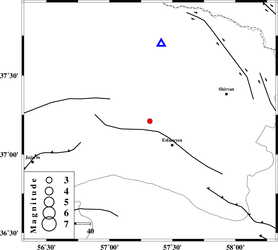
| Location | Lat:37.21 Lon: 57.32 |
| Region | Khorasan(north) Province, 29 km South of Bojnurd |
Nearest Cities |
|
| 13 km North of Eraj, Khorasan(north) Province | |
| 15 km North East of Cheharborj, Khorasan(north) Province | |
| 18 km North of Zarqabad, Khorasan(north) Province | |
| 23 km North West of Esfarayen, Khorasan(north) Province | |
| 29 km South of Bojnurd, Khorasan(north) Province | |
| Depth | 14 km |
| Agency | |
Faults within 150 km: |
|
| ESFARAYEN_F (Length: 111 km) , Distance to epicenter: 7 km | |
| ROBATE_QARABIL_F (Length: 168 km) , Distance to epicenter: 32 km | |
| JAJARAM_F (Length: 77 km) , Distance to epicenter: 51 km | |
| Number of Phases | 5 |
| RMS | 0.1 |
| Number of Stations | 4 |
| Error in Latitude | >2.3 km |
| Error in Longitude | 5.1 km |
| Error in Depth | 8.1 km |
Download waveform in seisan format
to download seisan software Click here
to access information about IIEES stations Click here
Amplitude | ||||||||
| UID | Agency | Station | Component | Amplitude | Period | Arrival Time | Proccessing Time | Signal Clip |
| 88755 | IIEES | SHRO | N | 52.5 | 0.38 | 2013-04-16 14:34:12 | 2013-04-16 04:29:00 | n |
Phase | ||||||||||||
| Agency | Station | Component | Phase Type | Phase Quality | First Motion | Observed Arrival Time | Time Residual | Loc. Flag | Input Weight | Distance | Azimuth | |
| IIEES | BJRD | Z | Pg | E | 2013-04-16 14:33:25 | -0.14 | y | 54.4 | 8 | |||
| IIEES | BJRD | E | Sg | E | 2013-04-16 14:33:32 | 0.08 | y | 54.4 | 8 | |||
| IIEES | MRVT | Z | Pg | E | 2013-04-16 14:33:35 | 0.04 | y | 120 | 295 | |||
| IIEES | SHRO | E | Sg | E | 2013-04-16 14:34:06 | -0.03 | y | 178 | 222 | |||
| IIEES | TABS | Z | Pn | E | 2013-04-16 14:34:12 | 0.08 | y | 396 | 183 | |||