
Magnitude |
3.4 |
| Date & Time (UTC) | 2013-04-19 13:06:35.4 |
| Date & Time (Local) | 1392/1/30 17:36:35.4 |
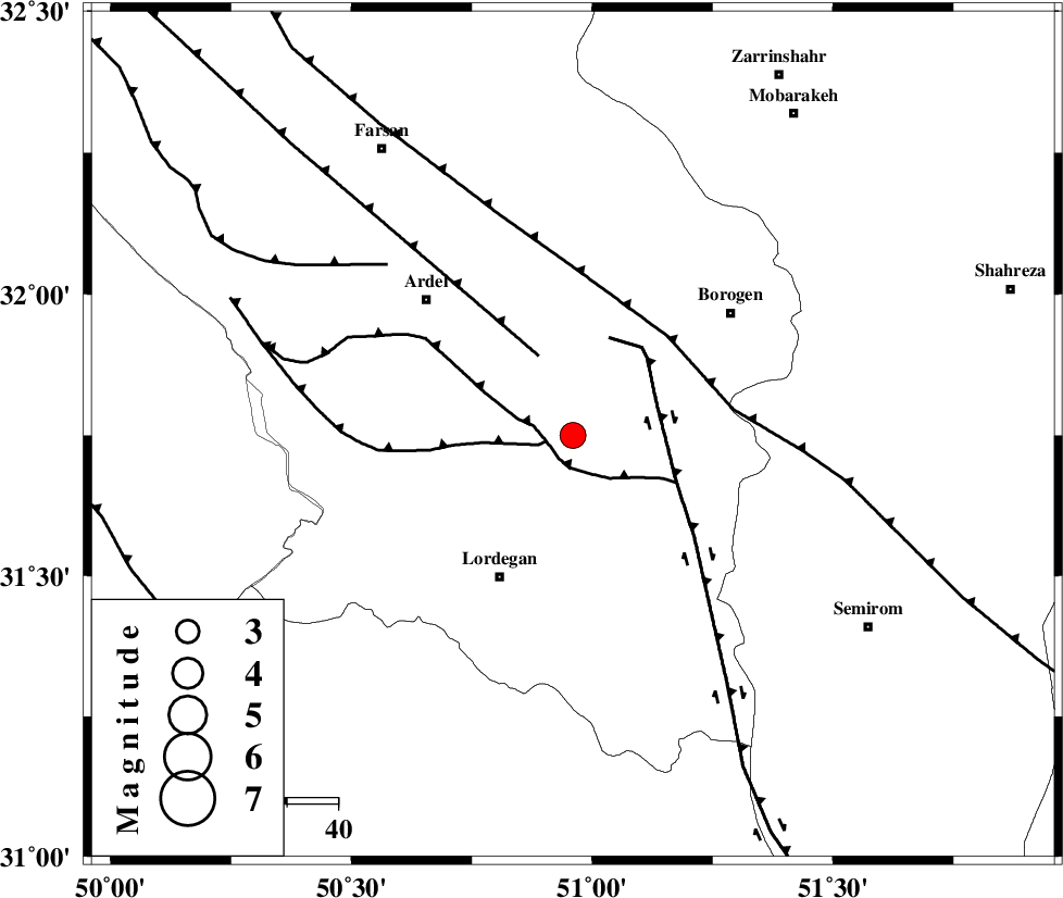
| Location | Lat:31.75 Lon: 50.96 |
| Region | Chaharmahal Bakhtiari Province, 31 km North-East of Lordegan |
Nearest Cities |
|
| 21 km North East of Armand-e olia, Chaharmahal Bakhtiari Province | |
| 22 km South of Baladaji, Chaharmahal Bakhtiari Province | |
| 23 km South West of Gandoman, Chaharmahal Bakhtiari Province | |
| 24 km North of Aluni, Chaharmahal Bakhtiari Province | |
| 30 km South East of Naghan, Chaharmahal Bakhtiari Province | |
| Depth | 15 km |
| Agency | |
Faults within 150 km: |
|
| SABZKUH_F (Length: 67 km) , Distance to epicenter: 5 km | |
| DOPOLAN_F (Length: 107 km) , Distance to epicenter: 5 km | |
| ARDAL_F (Length: 170 km) , Distance to epicenter: 17 km | |
| Number of Phases | 6 |
| RMS | 0.1 |
| Number of Stations | 6 |
| Error in Latitude | >5.1 km |
| Error in Longitude | 1.2 km |
| Error in Depth | 0 km |
Download waveform in seisan format
to download seisan software Click here
to access information about IIEES stations Click here
Amplitude | ||||||||
| UID | Agency | Station | Component | Amplitude | Period | Arrival Time | Proccessing Time | Signal Clip |
| 88828 | IIEES | KHMZ | N | 307.5 | 0.84 | 2013-04-19 13:07:48 | 2013-04-19 03:06:00 | n |
| 88829 | IIEES | KHMZ | E | 271.2 | 0.6 | 2013-04-19 13:07:49 | 2013-04-19 03:06:00 | n |
| 88830 | IIEES | SNGE | N | 34.4 | 0.64 | 2013-04-19 13:08:44 | 2013-04-19 03:06:00 | n |
Phase | ||||||||||||
| Agency | Station | Component | Phase Type | Phase Quality | First Motion | Observed Arrival Time | Time Residual | Loc. Flag | Input Weight | Distance | Azimuth | |
| IIEES | KHMZ | Z | Pn | E | 2013-04-19 13:07:13 | 0.09 | y | 240 | 337 | |||
| IIEES | GHVR | Z | Pn | E | 2013-04-19 13:07:20 | 0.04 | y | 304 | 5 | |||
| IIEES | ASAO | Z | Pn | E | 2013-04-19 13:07:23 | -0.07 | y | 323 | 345 | |||
| IIEES | YZKH | Z | Pn | E | 2013-04-19 13:07:26 | 0 | y | 351 | 77 | |||
| IIEES | CHTH | Z | Pn | E | 2013-04-19 13:07:40 | -0.07 | y | 462 | 2 | |||
| IIEES | SNGE | Z | Pn | E | 2013-04-19 13:07:45 | -0.04 | y | 500 | 319 | |||