
Magnitude |
4 |
| Date & Time (UTC) | 2013-04-19 20:22:34.6 |
| Date & Time (Local) | 1392/1/31 00:52:34.6 |
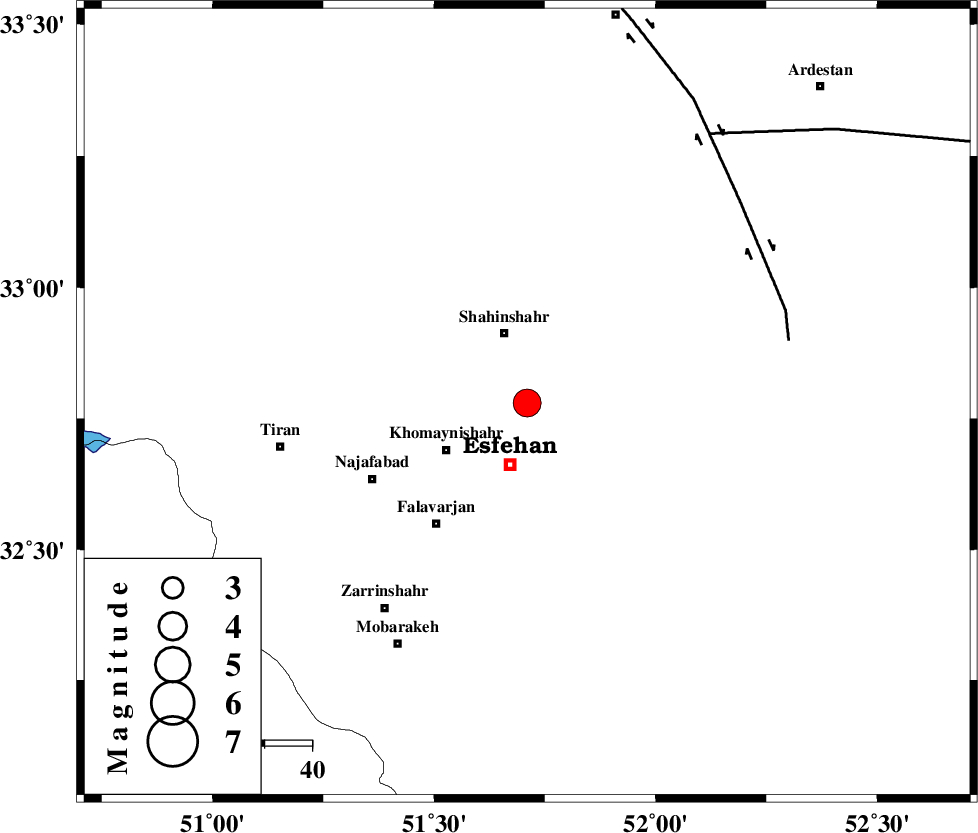
| Location | Lat:32.78 Lon: 51.71 |
| Region | Esfahan Province, 13 km North of Esfahan |
Nearest Cities |
|
| 2 km of Dolatabad, Esfahan Province | |
| 4 km of Dastgerd, Esfahan Province | |
| 6 km North of Khorzaq, Esfahan Province | |
| 8 km of Habibabad, Esfahan Province | |
| 9 km of Gaz, Esfahan Province | |
| Depth | 14 km |
| Agency | |
Faults within 150 km: |
|
| ZEFREH_F (Length: 124 km) , Distance to epicenter: 57 km | |
| CHAH_ZANGUL_F (Length: 123 km) , Distance to epicenter: 69 km | |
| MAIN_ZAGROS_R_F (Length: 1106 km) , Distance to epicenter: 108 km | |
| Number of Phases | 7 |
| RMS | 0.3 |
| Number of Stations | 6 |
| Error in Latitude | >5.3 km |
| Error in Longitude | 6.1 km |
| Error in Depth | 9.4 km |
Download waveform in seisan format
to download seisan software Click here
to access information about IIEES stations Click here
Amplitude | ||||||||
| UID | Agency | Station | Component | Amplitude | Period | Arrival Time | Proccessing Time | Signal Clip |
| 88839 | IIEES | GHVR | E | 1461.9 | 0.52 | 2013-04-19 20:23:33 | 2013-04-19 09:43:00 | n |
| 88840 | IIEES | GHVR | N | 1387.1 | 0.48 | 2013-04-19 20:23:40 | 2013-04-19 09:43:00 | n |
| 88841 | IIEES | KHMZ | E | 1430.5 | 0.24 | 2013-04-19 20:23:32 | 2013-04-19 09:43:00 | n |
Phase | ||||||||||||
| Agency | Station | Component | Phase Type | Phase Quality | First Motion | Observed Arrival Time | Time Residual | Loc. Flag | Input Weight | Distance | Azimuth | |
| IIEES | GHVR | Z | Pg | E | 2013-04-19 20:23:06 | -0.28 | y | 194 | 347 | |||
| IIEES | GHVR | E | Sg | E | 2013-04-19 20:23:29 | -0.01 | y | 194 | 347 | |||
| IIEES | KHMZ | Z | Pg | E | 2013-04-19 20:23:06 | -0.42 | y | 194 | 304 | |||
| IIEES | ASAO | Z | Pn | E | 2013-04-19 20:23:14 | 0.6 | y | 251 | 322 | |||
| IIEES | YZKH | Z | Pn | E | 2013-04-19 20:23:16 | -0.05 | y | 274 | 98 | |||
| IIEES | CHTH | Z | Pn | E | 2013-04-19 20:23:26 | 0.3 | y | 351 | 351 | |||
| IIEES | SHRO | Z | Pn | E | 2013-04-19 20:23:48 | -0.15 | y | 534 | 47 | |||