
Magnitude |
2.3 |
| Date & Time (UTC) | 2013-04-22 08:16:49.2 |
| Date & Time (Local) | 1392/2/2 12:46:49.2 |
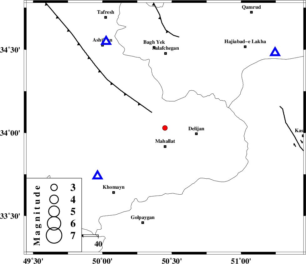
| Location | Lat:34.03 Lon: 50.45 |
| Region | Markazi Province, 12 km North of Mahallat |
Nearest Cities |
|
| 6 km of Khorheh, Markazi Province | |
| 12 km North of Mahallat, Markazi Province | |
| 16 km South West of Dudhak, Markazi Province | |
| 20 km North West of Nimur, Markazi Province | |
| 21 km North West of Delijan, Markazi Province | |
| Depth | 16 km |
| Agency | |
Faults within 150 km: |
|
| TAFRESH_F (Length: 117 km) , Distance to epicenter: 13 km | |
| INDES_F (Length: 98 km) , Distance to epicenter: 61 km | |
| KASHAN_F (Length: 44 km) , Distance to epicenter: 78 km | |
| Number of Phases | 5 |
| RMS | 0.1 |
| Number of Stations | 4 |
| Error in Latitude | >2.3 km |
| Error in Longitude | 1.8 km |
| Error in Depth | 3.7 km |
Download waveform in seisan format
to download seisan software Click here
to access information about IIEES stations Click here
Amplitude | ||||||||
| UID | Agency | Station | Component | Amplitude | Period | Arrival Time | Proccessing Time | Signal Clip |
| 88885 | IIEES | KHMZ | E | 201.5 | 0.24 | 2013-04-22 08:17:06 | 2013-04-22 09:37:00 | n |
Phase | ||||||||||||
| Agency | Station | Component | Phase Type | Phase Quality | First Motion | Observed Arrival Time | Time Residual | Loc. Flag | Input Weight | Distance | Azimuth | |
| IIEES | KHMZ | Z | Pg | E | 2013-04-22 08:16:59 | 0.03 | y | 55.2 | 235 | |||
| IIEES | ASAO | Z | Pg | E | 2013-04-22 08:17:01 | 0 | y | 69.9 | 326 | |||
| IIEES | GHVR | Z | Pg | E | 2013-04-22 08:17:04 | -0.11 | y | 88.7 | 55 | |||
| IIEES | GHVR | E | Sg | E | 2013-04-22 08:17:15 | 0.08 | y | 88.7 | 55 | |||
| IIEES | CHTH | Z | Pn | E | 2013-04-22 08:17:23 | 0.01 | y | 218 | 16 | |||