
Magnitude |
3 |
| Date & Time (UTC) | 2013-04-22 19:10:03.6 |
| Date & Time (Local) | 1392/2/2 23:40:03.6 |
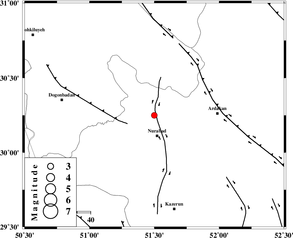
| Location | Lat:30.25 Lon: 51.5 |
| Region | Fars Province, 15 km North of Nurabad |
Nearest Cities |
|
| 1 km North of Masiri, Fars Province | |
| 8 km North of Fahlian-e olia, Fars Province | |
| 12 km East of Dehnumoqimi, Fars Province | |
| 15 km North of Nurabad, Fars Province | |
| 16 km North of Ahangari, Fars Province | |
| Depth | 46 km |
| Agency | |
Faults within 150 km: |
|
| KAZERUN_F (Length: 96 km) , Distance to epicenter: 4 km | |
| MISHAN_F (Length: 76 km) , Distance to epicenter: 21 km | |
| HZF3 (Length: 197 km) , Distance to epicenter: 44 km | |
| Number of Phases | 5 |
| RMS | 0.2 |
| Number of Stations | 3 |
| Error in Latitude | >5 km |
| Error in Longitude | 5.7 km |
| Error in Depth | 8.4 km |
Download waveform in seisan format
to download seisan software Click here
to access information about IIEES stations Click here
Amplitude | ||||||||
| UID | Agency | Station | Component | Amplitude | Period | Arrival Time | Proccessing Time | Signal Clip |
| 88892 | IIEES | AHRM | E | 328.2 | 0.36 | 2013-04-22 19:10:51 | 2013-04-22 08:34:00 | n |
| 88893 | IIEES | GHIR | E | 59.8 | 0.4 | 2013-04-22 19:11:22 | 2013-04-22 08:34:00 | n |
| 88894 | IIEES | GHIR | N | 62.6 | 0.48 | 2013-04-22 19:11:26 | 2013-04-22 08:34:00 | n |
Phase | ||||||||||||
| Agency | Station | Component | Phase Type | Phase Quality | First Motion | Observed Arrival Time | Time Residual | Loc. Flag | Input Weight | Distance | Azimuth | |
| IIEES | AHRM | Z | Pg | E | 2013-04-22 19:10:29 | -0.01 | y | 154 | 187 | |||
| IIEES | AHRM | E | Sg | E | 2013-04-22 19:10:48 | 0.15 | y | 154 | 187 | |||
| IIEES | GHIR | Z | Pn | E | 2013-04-22 19:10:39 | -0.46 | y | 261 | 146 | |||
| IIEES | GHIR | E | Sg | E | 2013-04-22 19:11:16 | 0.12 | y | 261 | 146 | |||
| IIEES | YZKH | Z | Pn | E | 2013-04-22 19:10:55 | 0.24 | y | 378 | 50 | |||