
Magnitude |
3.9 |
| Date & Time (UTC) | 2013-04-26 03:39:11.8 |
| Date & Time (Local) | 1392/2/6 08:09:11.8 |
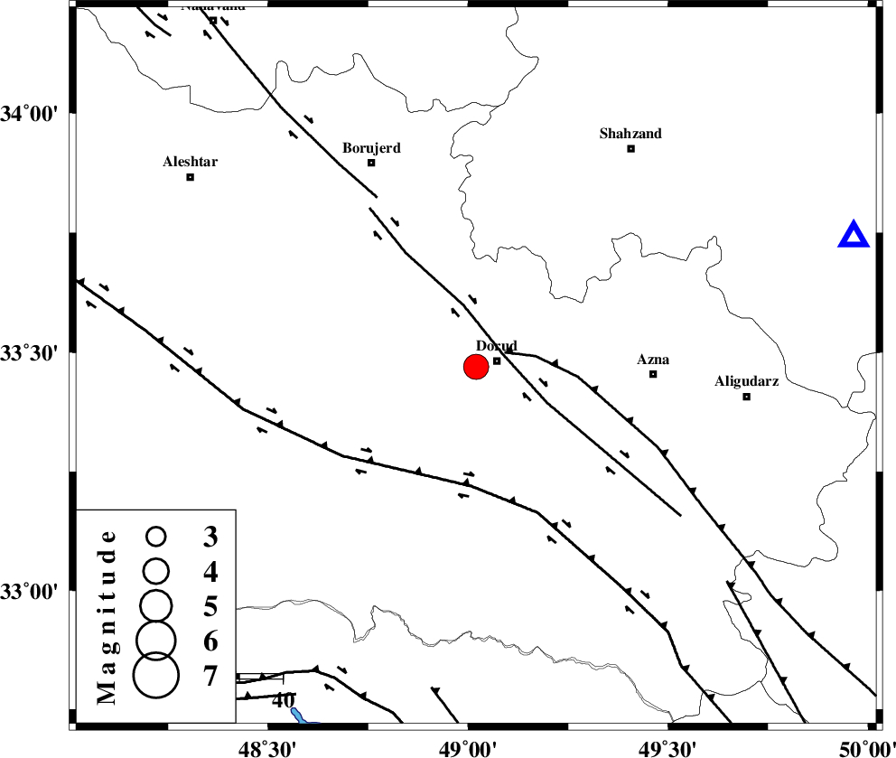
| Location | Lat:33.47 Lon: 49.02 |
| Region | Lorestan Province, 5 km Dorud |
Nearest Cities |
|
| 5 km of Dorud, Lorestan Province | |
| 7 km of Void, Lorestan Province | |
| 13 km West of Zhan, Lorestan Province | |
| 15 km North West of Heshmatabad, Lorestan Province | |
| 17 km South of Kagheh, Lorestan Province | |
| Depth | 18 km |
| Agency | |
Faults within 150 km: |
|
| DORUD (Length: 100 km) , Distance to epicenter: 7 km | |
| MAIN_ZAGROS_R_F (Length: 1106 km) , Distance to epicenter: 7 km | |
| HZF4 (Length: 492 km) , Distance to epicenter: 28 km | |
| Number of Phases | 7 |
| RMS | 0.1 |
| Number of Stations | 7 |
| Error in Latitude | >4.7 km |
| Error in Longitude | 3.2 km |
| Error in Depth | 8 km |
Download waveform in seisan format
to download seisan software Click here
to access information about IIEES stations Click here
Amplitude | ||||||||
| UID | Agency | Station | Component | Amplitude | Period | Arrival Time | Proccessing Time | Signal Clip |
| 88966 | IIEES | ASAO | E | 2470.1 | 0.52 | 2013-04-26 03:39:53 | 2013-04-26 05:12:00 | n |
| 88967 | IIEES | GHVR | N | 625.9 | 0.88 | 2013-04-26 03:40:24 | 2013-04-26 05:12:00 | n |
Phase | ||||||||||||
| Agency | Station | Component | Phase Type | Phase Quality | First Motion | Observed Arrival Time | Time Residual | Loc. Flag | Input Weight | Distance | Azimuth | |
| IIEES | GHVR | Z | Pn | E | 2013-04-26 03:39:48 | -0.09 | y | 234 | 61 | |||
| IIEES | GHVR | N | Sg | E | 2013-04-26 03:40:18 | 0.05 | y | 234 | 61 | |||
| IIEES | SNGE | Z | Pn | E | 2013-04-26 03:39:48 | -0.01 | y | 237 | 320 | |||
| IIEES | CHTH | Z | Pn | E | 2013-04-26 03:40:00 | -0.15 | y | 332 | 35 | |||
| IIEES | ZNJK | Z | Pn | E | 2013-04-26 03:40:03 | 0.15 | y | 356 | 355 | |||
| IIEES | YZKH | Z | Pn | E | 2013-04-26 03:40:25 | 0.11 | y | 535 | 101 | |||
| IIEES | SHRO | Z | Pn | E | 2013-04-26 03:40:46 | -0.01 | y | 699 | 64 | |||