
Magnitude |
2.2 |
| Date & Time (UTC) | 2013-04-29 17:13:51.4 |
| Date & Time (Local) | 1392/2/9 21:43:51.4 |
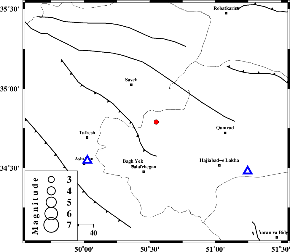
| Location | Lat:34.79 Lon: 50.55 |
| Region | Qom Province, 31 km South-East of Saveh |
Nearest Cities |
|
| 2 km North of Gazran, Qom Province | |
| 19 km South of Taraznahid, Markazi Province | |
| 21 km South East of Qareh chay, Markazi Province | |
| 28 km South East of Yalabad, Markazi Province | |
| 31 km South East of Saveh, Markazi Province | |
| Depth | 31 km |
| Agency | |
Faults within 150 km: |
|
| INDES_F (Length: 98 km) , Distance to epicenter: 16 km | |
| KUSHK_E_NOSRAT_F (Length: 230 km) , Distance to epicenter: 31 km | |
| S_PARANDAK_F (Length: 116 km) , Distance to epicenter: 57 km | |
| Number of Phases | 5 |
| RMS | 0.1 |
| Number of Stations | 4 |
| Error in Latitude | >1.5 km |
| Error in Longitude | 2.4 km |
| Error in Depth | 9.8 km |
Download waveform in seisan format
to download seisan software Click here
to access information about IIEES stations Click here
Amplitude | ||||||||
| UID | Agency | Station | Component | Amplitude | Period | Arrival Time | Proccessing Time | Signal Clip |
| 89001 | IIEES | ASAO | E | 162.4 | 0.36 | 2013-04-29 17:14:10 | 2013-04-29 07:17:00 | n |
Phase | ||||||||||||
| Agency | Station | Component | Phase Type | Phase Quality | First Motion | Observed Arrival Time | Time Residual | Loc. Flag | Input Weight | Distance | Azimuth | |
| IIEES | ASAO | Z | Pg | E | 2013-04-29 17:14:02 | 0.03 | y | 55.2 | 241 | |||
| IIEES | GHVR | Z | Pg | E | 2013-04-29 17:14:04 | 0.01 | y | 72.2 | 118 | |||
| IIEES | KHMZ | Z | Pg | E | 2013-04-29 17:14:12 | 0.1 | y | 128 | 205 | |||
| IIEES | KHMZ | E | Sg | E | 2013-04-29 17:14:28 | -0.1 | y | 128 | 205 | |||
| IIEES | CHTH | Z | Pg | E | 2013-04-29 17:14:13 | -0.05 | y | 135 | 23 | |||